
Columbia, SC Weather: Preparing for a Winter Weather Event
Columbia, South Carolina, and the surrounding Lowcountry are bracing for a significant winter weather event this weekend into early next week. The primary concern is the potential for freezing rain and ice accumulation, which could create hazardous conditions on roadways and lead to power outages. Stay informed and prepared with the latest updates.
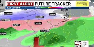
First Alert Weather Days Declared
Saturday and Sunday have been designated as First Alert Weather Days due to the increasing likelihood of winter precipitation. While there’s still some uncertainty in the forecast, the latest models, as of today, indicate a strong possibility of rain, freezing rain, or even ice impacting the region. This could significantly disrupt commutes and make travel dangerous.
Timing and Forecast Details
Rain is expected to begin moving into the area on Saturday. The most significant winter weather threat will develop later Saturday and into Saturday night as colder air settles in. Sunday will remain chilly, with precipitation likely transitioning back to rain during the daytime hours. However, lingering precipitation Sunday night and into Monday morning could fluctuate between rain and a wintry mix.
The Threat of Freezing Rain
The National Weather Service warns this is a multi-day event with a unique weather setup. The combination of warm, moist air aloft and subfreezing temperatures at the surface creates ideal conditions for freezing rain – a more dangerous scenario than snow in many cases. Freezing rain occurs when rain falls through a layer of subfreezing air and freezes upon contact with surfaces like roads, power lines, and tree branches. Even a small amount of ice accumulation can lead to treacherous travel conditions and potential power outages.
The risk of significant ice accumulation increases the further inland you travel. This weekend’s forecast differs from last weekend’s, where cold air and moisture were chasing each other. This time, the cold air is already in place, creating a more favorable environment for freezing precipitation.
What to Expect: Potential Impacts
- Winter Weather Watches/Advisories: Expect these to be issued in the coming days as the forecast becomes more certain.
- Accumulation Forecasts: The National Weather Service will provide specific accumulation forecasts and timing updates as the system approaches.
- Bitterly Cold Temperatures: Following the winter weather event, very cold air will move in early next week. Low temperatures inland could dip into the teens, while coastal areas will see lows in the low to mid-20s. Wind chills could reach the teens region-wide.
- Moderating Temperatures: Temperatures will begin to moderate early next week, with highs in the upper 40s to lower 50s on Tuesday and warmer conditions on Wednesday.
Preparation is Key
Forecasters advise all of southeast Georgia and southeast South Carolina to begin preparing now for at least minor winter weather impacts. This includes ensuring you have a well-stocked emergency kit, checking your heating system, and being prepared for potential power outages. Stay tuned to local news and weather updates for the latest information.
For real-time updates and alerts, download a reliable weather app like National Weather Service.
Source: WCSC Live 5 News


