
Boston Weather Alert: Cold Front to Bring Thunderstorms and a Refreshing Shift
If you’ve been feeling the heavy, humid air in the city, there is a change on the horizon. The current Boston weather pattern is about to shift as a cold front moves through New England, bringing a mix of unpredictable storms and, eventually, some much-needed relief from the humidity.
What to Expect This Wednesday
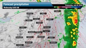
The day will start off deceptively calm. Wednesday morning will likely be mostly cloudy and dry, but don’t let that fool you. As the day progresses, an advancing cold front will spark a round of scattered showers and thunderstorms.
The highest probability of precipitation will hit Boston during the afternoon and evening hours. While most storms will be isolated, there is a risk that one or two could turn severe. The primary concern for residents and travelers will be strong, damaging wind gusts caused by powerful downdrafts as the front pushes through.
Temperature and Humidity: From Muggy to Mild
We are starting the day with that classic “muggy” New England feel, with dew points climbing into the upper 60s and low 70s. However, the silver lining of this cold front is the arrival of drier air.
- n
- City Highs: Expect temperatures to reach the low to mid-80s.
- Coastal Highs: Due to the persistent southerly wind and sea breeze, the immediate coast will likely stay cooler, peaking in the upper 70s.
- The Humidity Drop: As the afternoon rolls on, dew points will plummet into the comfortable 50s. While the city might not feel this relief until nighttime, it sets the stage for a much more pleasant atmosphere.
For real-time radar updates and severe weather alerts, it is always recommended to check the National Weather Service (NOAA) to stay safe during gusty conditions.
Regional Weather Breakdown
The impact of this system extends beyond the city limits. Here is what the rest of the region can expect:
Massachusetts and Rhode Island
- n
- Central/Western Mass: Mostly cloudy with a few spot showers; humidity drops late afternoon.
- Southeastern Mass: Breezy conditions with showers possible both morning and afternoon.
- Cape Cod & Islands: A breezy day with spotty showers throughout the morning and evening.
- Rhode Island: Highs in the upper 70s to low 80s with scattered shower chances.
Northern New England
- n
- New Hampshire: Morning thunderstorms likely, with highs reaching the low 80s in the south.
- Vermont & Maine: A muggy start turning drier in Vermont, while Maine will hold onto the humidity a bit longer. Highs will settle in the upper 70s to low 80s.
- Connecticut: Expect mostly cloudy skies and potential thunderstorms, remaining muggy for most of the day.
Looking Ahead: A Perfect Weekend?
If you can weather the Wednesday storms, there is a reward waiting. The passing front will usher in a period of cooler, drier air for the end of the work week. Looking toward Saturday and Sunday, Boston weather looks promising, with highs settling comfortably in the 70s across most of New England.
Whether you are planning a coastal walk or a city outing, the upcoming weekend promises the kind of mild weather that makes this time of year in New England truly special.



