Atlantic Weather Update: New Low-Pressure System Monitored Near Bermuda
Atlantic Weather Update: New Low-Pressure System Monitored Near Bermuda
The Atlantic basin remains under close observation as the National Hurricane Center (NHC) tracks a new area of low pressure forming along a front boundary. For those keeping an eye on tropical activity, here is everything you need to know about the current system and the state of the hurricane season.
Potential Development Near Bermuda
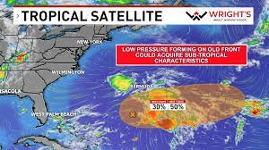
Currently situated a few hundred miles south of Bermuda, this low-pressure system is showing signs of potential growth. Forecasters suggest that the surrounding environment could allow the system to acquire subtropical characteristics over the coming weekend.
According to the latest data, there is a 30% to 50% chance of development within the next two to seven days. However, the window for growth is narrow, as conditions are expected to become unfavorable for further development by early next week.
Is the United States at Risk?
For residents of the East Coast and Florida, there is good news: this system poses no threat to Florida or the United States. Due to typical November climatology, the system is being pushed further out to sea, driven by hostile upper-level winds and troughing that prevent it from tracking toward land.
A Below-Average Hurricane Season
As we approach the end of the cycle, this year’s activity has been notably quiet compared to historical averages. Here is a quick breakdown of the season’s statistics:
- n
- Named Storms: 10
- Hurricanes: Only 1
- Overall Trend: Well below average activity.
The lack of significant storm development this year highlights the complex interplay of atmospheric conditions that dictate the intensity of the Atlantic hurricane season.
Looking Ahead
While the current threat is minimal, staying informed is key to disaster preparedness. Weather patterns can shift rapidly, and monitoring official sources ensures you have the most accurate information for your region.
Stay tuned for more weather updates and keep an eye on the latest advisories to stay safe and prepared.
📰 You May Also Like