
Prepare for the Chaos: A Historic Weather System is Sweeping Through Alberta
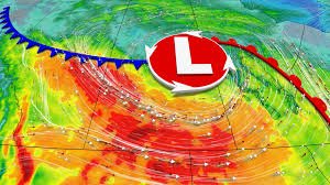
Residents across the Prairies are being urged to stay vigilant as a powerful and potentially record-setting low-pressure system prepares to collide with the region. This isn’t just your average spring shower; weather analysts suggest this system could set a new record for the lowest pressure ever recorded in the month of May.
If the pressure drops below 980 millibars as it moves across the central Prairies, we will be witnessing a historic meteorological event. This deep low-pressure gradient typically triggers volatile weather, including intense precipitation and dangerous wind speeds.
⚠️ Extreme Wind Alerts: What You Need to Know
The most immediate concern for Albertans and residents of Saskatchewan is the arrival of damaging winds. Expect a rough ride starting Thursday, with gust speeds potentially reaching 80-100+ km/h. These winds are strong enough to cause structural damage and widespread power outages.
Safety Tips for High Winds:
- n
- Secure all loose outdoor furniture, garbage cans, and decorations.
- Avoid parking vehicles under large trees or unstable structures.
- Prepare an emergency kit in case of power failures.
- Stay indoors during the peak of the wind gusts.
n
n
n
n
From Thunderstorms to Snow: A Weather Rollercoaster
The transition will be jarring. While Wednesday may offer some mild temperatures, instability is rising. There is a significant threat of rain and thunderstorms, particularly along the Alberta foothills and extreme southern regions.
In northern Alberta, the situation is even more critical. Forecasts suggest 30-60 mm of rain, which significantly heightens the risk of local flooding. However, the real surprise comes with the arrival of a sharp cooldown. Cold air will push south, transforming rain into snow and icy precipitation across northeastern Alberta and far northern Saskatchewan.
Will the Long Weekend be Ruined?
If you have outdoor plans for the upcoming long weekend, you may want to have a Plan B. A significant temperature contrast is expected, with some areas seeing single-digit daytime highs. While the south may hold onto some warmth, the Rockies are likely to see snow, and a general unsettled, cool pattern will dominate the region.
For real-time updates and official warnings, we recommend monitoring Environment Canada to ensure you have the most accurate local data.
Summary of Expected Impacts
| Region | Primary Threat | Expected Intensity |
|---|---|---|
| Alberta & Saskatchewan | Wind Gusts | 80-100+ km/h |
| Northern Alberta | Heavy Rain/Flooding | 30-60 mm |
| Far North / Rockies | Snowfall | 2-10 cm |
Stay safe, stay informed, and keep an eye on the skies as this historic Alberta storm moves through the region.


