Calgary Weather: Prepare for Potential Travel Disruptions This Long Weekend
If you’re hoping to kick off the Easter long weekend with a road trip, Environment and Climate Change Canada is advising motorists to prepare for potentially challenging driving conditions. A storm system is expected to sweep through the Calgary and Edmonton areas starting Wednesday night and continuing into Thursday.
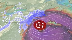
Special Weather Statement Issued for Calgary & Surrounding Areas
Environment Canada has issued a “special weather statement” for Calgary and the surrounding region. While initial forecasts predicted up to 20 cm of snow, the latest update suggests accumulations will likely be around 5 cm. However, even a smaller amount of snow can create hazardous conditions.
“It could start as rain or a rain-snow mix,” explains Leslie Horton, Global Calgary’s traffic and weather specialist. “It will continue overnight tonight and into tomorrow, likely until around dinnertime.”
What to Expect: Reduced Visibility & Slippery Roads
Temperatures hovering around the freezing mark make predicting exact snowfall amounts difficult. Meteorologists warn that the snow may significantly reduce visibility and create slippery road conditions. Motorists are urged to allow extra travel time and exercise caution.
Areas most affected are expected to include:
- Highway 2
- Parts of Highway 1
- Areas west of Calgary
The special weather statement covers a broad area, stretching from just north of Fort Macleod in the south to Ponoka in the north, and from Canmore in the west to Drumheller in the east.
Edmonton Weather Outlook
While not directly included in the special weather statement, Edmonton is also anticipating some flurries starting late Wednesday afternoon, with up to 2 cm of snow expected before the storm passes on Thursday evening. Phil Darlington, Global Edmonton’s weather specialist, notes that the heaviest snowfall will be further south.
“The majority of the snow is going to affect the areas from Red Deer further south, but we see a little bit still trailing up further west of Edmonton across the highway into the Whitecourt area, with some scattered flurries still closer to Peace River for that (Thursday) morning commute,” Darlington stated.
Looking Ahead: Melting Snow & Improved Conditions
The good news? Temperatures across southern and central Alberta are forecast to rise to the mid to high single digits on Friday. This warmer weather should melt any accumulated snow quickly, leading to improved driving conditions just in time for the Easter long weekend. Stay informed about the latest conditions by checking The Weather Network.
Stay safe and plan accordingly!