
Tropical Storm Bertha: What You Need to Know About the Impending Gulf Coast Weather
Residents along the northeastern Gulf Coast are on high alert as Tropical Depression Two continues to strengthen. Forecasters expect the system to intensify into a named storm tonight or Monday, officially becoming Tropical Storm Bertha. With heavy rain and powerful wind gusts on the horizon, staying informed is critical for those in the projected path.
To get a more precise understanding of the storm’s core, a Hurricane Hunter aircraft is scheduled to fly into the system this Sunday. This mission will provide vital data on wind speeds, atmospheric pressure, and the surrounding weather environment to refine current predictions.
Key Impacts and Potential Hazards
While the center of the storm may remain offshore, the associated rain bands and wind patterns are expected to bring significant disruption to the coast. Here is the detailed breakdown of the expected impacts:
- n
- Heavy Rainfall: Widespread totals of 2 to 4 inches are anticipated, with extreme thunderstorms potentially dumping up to 8 inches of rain. This increases the risk of flash flooding in low-lying areas.
- Storm Surge: The Big Bend region of Florida, specifically from Indian Pass to Chassahowitzka, could see water levels rise 1 to 3 feet above normal.
- Dangerous Winds: Tropical storm conditions are likely, with wind gusts expected to exceed 40 mph along the coastline.
Warning Zones and Movement
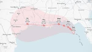
A Tropical Storm Watch has already been issued for the Florida Panhandle, stretching from the Ochlockonee River west to the Florida-Alabama border. Residents in these zones should prepare for potential tropical storm conditions within the next 36 to 48 hours.
Due to very weak steering currents, Tropical Storm Bertha is expected to move slowly toward the north-northwest. Although the system is currently battling some dry air, light wind shear may allow for additional strengthening as it approaches the coasts of Alabama, Mississippi, and Louisiana by midweek.
The Bigger Picture: Atlantic Hurricane Season
The emergence of Bertha comes after a relatively quiet period in the Atlantic Ocean Basin. The last named storm, Tropical Storm Arthur, made landfall near Galveston, Texas, in mid-June. According to the National Oceanic and Atmospheric Administration (NOAA), the current El Niño pattern is contributing to a lower-than-average number of named systems this season.
For real-time tracking and official warnings, we recommend monitoring the National Hurricane Center (NHC) to ensure your family and property remain safe.



