
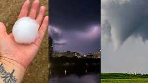
Understanding the Shift in Edmonton Weather: Heat Waves and Severe Storms
For many residents, Edmonton weather is known for its dramatic swings, but recent years have brought a more concerning trend. From oppressive humidity to sudden, violent thunderstorms, the atmosphere across the Canadian Prairies is becoming increasingly volatile. But why is this happening, and what does it mean for the safety of Albertans?
According to atmospheric experts, the intense heat waves blanketing Canada aren’t just uncomfortable—they are acting as a catalyst for severe weather events, including the dreaded tornadoes.
The Science of the “Heat Dome”
You may have heard meteorologists mention a “heat dome” during recent weather reports. To put it simply, a heat dome acts like a lid on a boiling pot of water. It traps solar radiation and heat, feeding back into itself day after day. This creates a high-pressure system that compresses air and pushes it downward, causing temperatures to soar.
While the center of the dome is scorching, the edges—often referred to as the “ring of fire”—are where the most dangerous weather occurs. This is where the clash of temperature and moisture triggers severe thunderstorms.
Why Humidity is the “Fuel” for Tornadoes
It is a common misconception that heat alone causes tornadoes. In reality, the danger lies in water vapour. As temperatures rise, the atmosphere can hold more moisture. Professor Kent Moore from the University of Toronto explains that water vapour acts as fuel for the atmosphere.
- n
- Energy Release: When water vapour condenses into liquid (rain), it releases massive amounts of energy.
- Storm Intensity: This energy powers thunderstorms, which can quickly evolve into tornadic events if the conditions are right.
- Climate Impact: Due to global warming, these extreme heat events are now twice as likely to occur, making peak temperatures higher than historical norms.
The Expansion of “Tornado Alley” into the Prairies
Historically, the most intense tornado activity was concentrated in the U.S. Midwest and parts of Ontario and Quebec. However, data from the Northern Tornadoes Project suggests a shift. While year-to-year variation is high, the Prairies—including Alberta and Saskatchewan—have seen a noticeable increase in stormy patterns.
The geographical corridor known as “Tornado Alley” is effectively seeing more activity in the West. This means that Edmonton weather and the surrounding rural areas are increasingly susceptible to high-wind events and flash flooding.
Staying Safe: The Challenge of Forecasting
One of the most frightening aspects of these storms is how quickly they develop. While Environment Canada provides critical alerts, tornadoes remain incredibly difficult to forecast with precision. Often, warnings are issued with less than 30 minutes of lead time.
Quick Tips for Severe Weather Safety:
- n
- Stay tuned to local weather apps and Environment Canada alerts.
- Identify the safest room in your home (typically a basement or an interior room on the lowest floor).
- Avoid driving during severe thunderstorm warnings to prevent being caught in flash floods or debris.
As climate change continues to influence regional weather patterns, staying informed is the best defense against the unpredictable nature of the Canadian summer.



