
Super Typhoon Bawi Alert: Potential Devastation and Safety Guidelines for East China
The arrival of Super Typhoon Bawi, described by meteorologists as a “behemoth” due to its massive size, has put weather authorities and residents in East China on high alert. As the ninth typhoon of the year, Bawi’s intensity and scale present significant risks to coastal and inland regions.
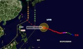
According to the latest reports from the Jiangxi Provincial Meteorological Observatory, the center of the super typhoon was positioned approximately 1,980 kilometers southeast of Keelung, Taiwan. It is currently moving westward at a speed of 25 to 30 kilometers per hour, heading straight toward the waters east of Taiwan.
Predicted Paths: Where Will Super Typhoon Bawi Hit?
Meteorological experts are closely monitoring two primary potential trajectories for the storm, both of which pose a threat to various regions:
- n
- Scenario A: The typhoon may make landfall along the coasts of Zhejiang and Fujian around July 11th. In this scenario, it would move northward, bringing torrential rains to East China. Specifically, northeastern Jiangxi could see rainfall between 40-80mm, with mountainous areas like Wuyi and Huaiyu potentially exceeding 150mm.
- Scenario B: The storm could first make landfall in Taiwan and then strike Fujian a second time. It would then move northwest through Jiangxi—entering from Fuzhou and Shangrao as a strong tropical storm—before exiting via Jiujiang. This transit is expected to last approximately 10 hours.
Expected Weather Impacts: Heavy Rain and Gale-Force Winds
Regardless of the final path, significant weather disruptions are inevitable. Experts warn that Jiangxi Province will experience noticeable strong winds and heavy precipitation.
From the evening of July 11th to July 12th, northern and north-central Jiangxi are expected to face heavy to torrential rains, with cumulative totals between 50-100mm. Local mountainous regions could see extreme rainfall exceeding 200mm. Furthermore, gusty winds reaching Level 9 are anticipated in river basins, plains, and high-altitude scenic spots.
Critical Safety Precautions: How to Prepare
Given the unpredictable nature of tropical cyclones, the meteorological department urges all sectors and the general public to take immediate preventive measures. To ensure safety, follow these guidelines:
- Infrastructure Check: Inspect and reinforce power lines, communication facilities, billboards, and temporary sheds. Remove or secure any unstable structures.
- Operational Safety: Suspend all outdoor work, high-altitude operations, and water-based activities during the storm’s peak.
- Transportation & Travel: Avoid traveling to high-mountain scenic areas and be cautious of land and water transport disruptions.
- Stay Informed: Closely monitor official weather updates and early warning systems to adjust your plans in real-time.
For more information on how to prepare for extreme weather events, you can visit the World Meteorological Organization (WMO) for global standards on weather safety.
Disclaimer: Typhoon paths and intensity are subject to change. Please rely on local government alerts for the most accurate and timely evacuation or safety orders.



