
Alert: Severe Weather Heading for Southern Ontario
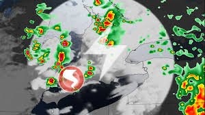
Residents across Southern Ontario are urged to remain vigilant as a low-pressure system moving over the Great Lakes is expected to trigger widespread rain and scattered thunderstorms this Thursday. While some rain is expected, meteorologists warn that certain cells could evolve into severe weather, bringing risks of large hail, funnel clouds, and potentially isolated tornadoes.
The storm activity is projected to intensify during the afternoon and evening hours. If you are in the region, keeping a close eye on active weather alerts is essential for your safety.
What to Expect: Hail and Funnel Clouds
The atmospheric conditions are becoming increasingly unstable. The combination of warm surface air and cold air in the upper atmosphere is creating a prime environment for “pop-up” thunderstorms.
Key threats include:
- n
- Large Hail: Some storms may produce hail ranging from 2 to 3 cm in diameter.
- Funnel Clouds: High lapse rates make Southwestern Ontario and the Lake Huron shoreline particularly susceptible to funnel clouds.
- Tornado Potential: There is a slight risk of weak landspout tornadoes emerging during the late afternoon or evening.
Travel Impacts and Local Rainfall
With 5-15 mm of rainfall expected—and higher amounts in localized areas—commuters should prepare for challenging conditions. Water-laden roads and reduced visibility could lead to hazardous driving. Furthermore, wind gusts between 30-50 km/h are expected, with peak gusts reaching up to 80 km/h during the height of the thunderstorms.
For real-time safety guidelines during these events, you can refer to Environment Canada for official warnings.
A Record-Breaking June for Rain
This severe weather event comes on the heels of an exceptionally wet month. Many regions in Southern Ontario have already met or exceeded their monthly rainfall averages for June:
- n
- Toronto: 80 mm recorded (Monthly normal: 81 mm).
- Hamilton: 103 mm recorded (Monthly normal: 78 mm).
Looking Ahead: Weekend Sunshine and July Heat
The good news? The instability will clear up shortly. Southern Ontario can look forward to partly sunny skies this weekend, with highs reaching the mid-to-upper 20s by Sunday.
However, prepare for a heatwave next week. Temperatures are expected to climb above seasonal norms, with humidity levels potentially pushing the humidex beyond 40. While cloud cover may moderate the peak heat, warm and humid nights are practically guaranteed.
As we move into the second week of July, a cooling trend is expected to return, bringing temperatures back to seasonal averages by mid-to-late July.
Stay tuned to local forecasts and ensure your emergency kits are ready for any sudden shifts in weather.


