
Tropical Storm Arthur: The First Major Threat of the 2026 Hurricane Season
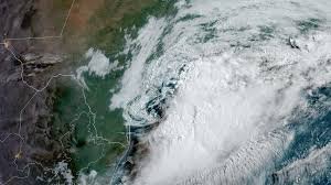
The 2026 Atlantic hurricane season has kicked off with a sobering reminder of nature’s power. Tropical Storm Arthur, the first named storm of the year, made landfall off the coast of Texas on Wednesday morning, triggering a wave of devastating floods across the Gulf Coast. From Texas to Georgia, millions are currently under weather alerts as the system moves inland.
As of 8 p.m. ET, the National Hurricane Center (NHC) reported that Arthur’s centre had moved approximately 10 miles northwest of Galveston, Texas. The storm is expected to continue its trajectory across extreme southeast Texas and southwest Louisiana, bringing hazardous conditions throughout the week.
A Deadly Toll: The Impact of Flash Flooding
Even before officially forming, the moisture from Arthur created a volatile environment. Tragically, the storm has already claimed at least two lives in Texas, highlighting the extreme danger of floodwaters.
- n
- Bandera County: A woman lost her life after her vehicle was swept into a flooded creek. Despite emergency efforts and swift water rescue teams, her vehicle was found completely submerged several miles downstream.
- Montgomery County: A 15-year-old boy drowned in a flooded retention pond in Magnolia. Authorities used sonar technology to recover the body, issuing a solemn warning to the public about the dangers of playing near flood-prone areas.
Regional Crisis: From Texas to the Florida Panhandle
The scale of the flooding is immense. Parts of eastern Texas, Louisiana, and Mississippi have received more than a month’s worth of rain in just three days. In some areas, the rainfall was so intense that this monthly total fell within a matter of hours.
Major cities currently facing a Level 3 out of 4 flooding threat include:
- New Orleans and Lake Charles, Louisiana
- Biloxi, Mississippi
- Mobile, Alabama
- Pensacola, Florida
According to the National Weather Service (NWS), rainfall rates could reach a staggering 3 to 4 inches per hour in some regions, with total accumulations potentially hitting 20 inches in isolated spots.
Emergency Response and Disaster Declarations
In response to the crisis, Texas Governor Greg Abbott has issued a disaster declaration for 101 counties, activating state emergency resources to assist stranded residents. In cities like Waco and Shreveport, emergency crews have worked tirelessly to rescue drivers trapped in submerged vehicles and families stranded in homes with waist-deep water.
Forecast Timeline: What to Expect Next
If you are located in the Southern United States, please stay vigilant. Here is the projected timeline for the remainder of the storm’s impact:
- Wednesday Night: While rain is diminishing on the upper Texas coast, the risk increases for Louisiana and the western Florida Panhandle.
- Thursday: Heavy rains will persist in eastern Louisiana, Mississippi, and Alabama, spreading east toward Georgia by the evening.
- Friday: A cold front may trigger isolated flash flooding across much of the South, with the highest risk remaining in southern Alabama, southern Mississippi, and the Florida Panhandle.
Stay safe, avoid driving through flooded roadways, and continue to monitor local weather alerts for real-time updates.


