
Urgent Weather Update: Kansas City Under Severe Storm Watch
Residents across the Kansas City metro area are on high alert as a series of severe weather systems move through the region. From sudden tornado warnings to critical flash flood alerts, the atmosphere across eastern Kansas and western Missouri has become increasingly unstable, prompting urgent warnings for millions of residents.
What is Happening Right Now?
The region is currently under a severe thunderstorm watch, with activity continuing to develop. The weather has been volatile, with warnings being issued and canceled in rapid succession as cells move across the landscape.
Recent reports indicate a high level of instability, leading to several critical alerts:
- n
- Tornado Warnings: Temporary alerts were issued for Clay and Jackson counties, including high-risk areas like Independence and Raytown. While some warnings have been canceled, the threat remains fluid.
- Flash Flood Warnings: Immediate danger has been flagged for Wyandotte County (KS) and Clay and Platte counties (MO).
- Severe Thunderstorms: Widespread warnings have affected multiple counties, bringing the threat of damaging winds and large hail.
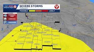
Affected Areas: Who Should Be Alert?
The severe weather impact spans across state lines, affecting a vast number of counties. If you are in the following areas, please remain vigilant:
In Kansas:
Johnson, Wyandotte, Leavenworth, Miami, and Linn counties.
In Missouri:
Jackson, Clay, Platte, Cass, Ray, Lafayette, Johnson, Bates, Henry, Carroll, Cooper, Howard, Pettis, and Saline counties.
The Forecast: What to Expect Next
Meteorologists suggest that the primary concern for the remainder of the event is damaging wind gusts and the potential for large hail. While the overall risk of a major tornado remains low, the instability of the warm air and sunshine continues to fuel storm development.
Storms are expected to organize into clusters or lines, moving in an east-northeast direction. Some neighborhoods may experience torrential rain, while others might remain completely dry—a typical characteristic of these volatile weather patterns.
How to Stay Safe
When a tornado Kansas City warning or severe storm alert is issued, seconds count. Here are a few essential safety tips:
- Seek Shelter Immediately: Move to a basement or an interior room on the lowest floor of a sturdy building.
- Avoid Windows: Stay away from glass doors and windows to avoid injury from flying debris.
- Stay Informed: Keep a battery-powered weather radio nearby or enable emergency alerts on your smartphone.
For real-time tracking and official government alerts, we highly recommend monitoring the National Weather Service (NWS) and the National Oceanic and Atmospheric Administration (NOAA).


