
Staying Cool in the Valley: What to Expect from the Phoenix Weather
If you’ve stepped outside today, you already know that the heat is officially here. Phoenix weather has kicked off the week with highs hitting the 100-degree mark across the Valley, signaling the arrival of the intense Arizona summer heat.
However, it’s not just about the temperature. Residents should stay alert for changing atmospheric conditions as we head into the holiday weekend.
Tonight’s Outlook: Dust and Gusty Winds
While the Valley remains hot, activity near Tucson could bring some turbulence our way. Showers and thunderstorms in the Tucson area are expected to trigger gusty winds and pockets of blowing dust moving northward this evening.
- n
- Primary Impact Areas: Areas such as Queen Creek may experience gusts around 25 mph.
- Metro Phoenix: Some weakening gusts may drift into the city later tonight.
Memorial Day Weekend Forecast
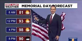
Planning a get-together for Memorial Day? The good news is that the weather looks mostly favorable. While there is a slight chance of a brief sprinkle in the Valley due to storms in the higher terrain to the east, most of us will stay dry.
The Temperature Breakdown:
- Monday (Memorial Day): Mostly sunny with highs around 98°F.
- Tuesday: Continuing the trend with highs near 97°F.
- Wednesday: Expect increased breezes with gusts between 25 to 30 mph, while temperatures hold in the mid-90s.
A Welcome Break: The Mid-Week Cooling Trend
For those struggling with the triple digits, relief is on the horizon. A shift in air mass will bring cooler temperatures starting Thursday, dropping highs into the low 90s.
Friday is shaping up to be the highlight of the week, featuring a refreshing morning low in the mid-60s and a very pleasant afternoon high of around 92°F. Enjoy it while it lasts, as temperatures are expected to climb back into the upper 90s by next weekend.
High Country Alert: Flagstaff and White Mountains
If you are heading north to the High Country, be prepared for more volatile weather. Southeast Arizona has a 30% to 40% chance of storms tonight, and there is a high probability of scattered showers and thunderstorms on Monday across Flagstaff and the White Mountains.
For those traveling back home to the Valley, the storms should gradually taper off by late Monday night.
For real-time updates and severe weather warnings, we recommend checking the National Weather Service to stay safe and informed.



