
Urgent Weather Alert: Severe Thunderstorms and Tornado Risks in Southern Ontario
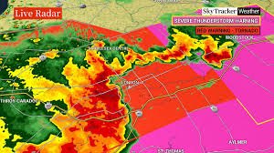
Residents across Southern Ontario are on high alert this evening as a red warning for severe thunderstorms has triggered multiple tornado warnings. Environment Canada has issued urgent alerts for several regions, warning of the potential for destructive winds, large hail, and life-threatening tornadoes as a powerful storm system moves through the province.
Affected Areas and Current Warnings
The storm system is moving rapidly, creating a volatile weather situation. Environment Canada has specifically issued tornado warnings for the following regions:
- n
- Brantford and the County of Brant
- Simcoe-Delhi-Norfolk
- Woodstock-Tillsonburg-Oxford County
As the system tracks east at approximately 80 km/h, the Niagara Region is also in the path of these volatile cells. Reports indicate that tornadoes have already been spotted near Burgessville and Springford, highlighting the immediate danger to these communities.
What to Expect: Destructive Winds and Hail
According to Anthony Farnell, chief meteorologist at Global News, the current atmospheric conditions are prime for “quick tornado spin-ups.” Beyond the risk of tornadoes, the region is facing widespread straight-line winds that could reach devastating speeds.
Key Weather Threats:
- n
- Wind Gusts: Potential for winds between 110 and 130 km/h, capable of causing significant structural damage.
- Hail: Hailstones up to 2.5 centimetres in diameter are expected.
- Rainfall: Locally intense rainfall may lead to flash flooding in low-lying areas.
Immediate Safety Actions: How to Protect Yourself
Environment Canada has emphasized that this is a “very dangerous and potentially life-threatening situation.” If you are in an affected area, do not wait for the storm to arrive before taking action.
Follow these emergency protocols immediately:
- n
- Seek Shelter: Move immediately to a basement, an interior room on the lowest floor, or a sturdy reinforced building.
- Avoid Windows: Stay away from glass doors and windows to prevent injuries from flying debris.
- Stay Informed: Continuously monitor local weather forecasts and official alerts from Environment Canada.
While the current heat and humidity are expected to break tonight, the immediate priority remains safety and vigilance. Residents in Norwich, Otterville, Princeton, Teeterville, Burford, Scotland, and Waterford are urged to remain indoors until the red warning is lifted.



