
Severe Thunderstorm Alert: Yellow Watch Issued as Powerful Cold Front Hits Southern Ontario
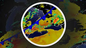
Southern Ontario’s brief taste of summer is coming to a crashing halt. A powerful cold front is sweeping across the province, triggering a yellow watch for severe thunderstorms that could bring damaging winds, torrential rain, and a shocking temperature plunge before Wednesday morning.
As heat and humidity peak on Tuesday afternoon, the atmosphere is becoming a powder keg, setting the stage for highly organized storm cells. Whether you are commuting or staying indoors, staying informed is critical to your safety.
What to Expect: Wind, Hail, and Heavy Rain
Unlike the scattered activity seen previously, this incoming weather system is more structured and potentially more destructive. Forecasters are warning of several high-risk elements:
- n
- Damaging Wind Gusts: Strong winds could lead to power outages and property damage.
- Large Hail: Some communities may experience significant hail, posing a risk to vehicles and agriculture.
- Torrential Rainfall: Rapidly changing conditions could lead to localized flash flooding, especially in urban areas.
- Tornado Risk: While not the primary threat, the chance of tornado formation cannot be entirely ruled out.
High-Risk Areas: The Highway 401 Corridor
The most intense activity is expected to concentrate along the Highway 401 corridor. The storms are predicted to form mid-to-late Tuesday afternoon near Lake Huron and Georgian Bay, including the city of Barrie.
From there, the line of severe weather will shift south and east, impacting the Greater Toronto Area (GTA), London, Windsor, and Sarnia. If you are planning an evening commute, be prepared for rapidly deteriorating visibility and hazardous road conditions.
The Big Chill: A Dramatic Temperature Plummet
The most startling aspect of this cold front is the sudden temperature drop. Residents will experience a weather transition that feels like jumping from July to April in less than 24 hours. Some regions may see temperatures plummet by more than 20°C.
- Barrie: Falling from a warm 28°C Tuesday afternoon to a chilly 6°C by Wednesday morning.
- London: Dropping from near 30°C to roughly 7°C overnight.
How to Stay Safe During Severe Thunderstorms
When a yellow watch or severe thunderstorm warning is in effect, taking precautions can save lives. For more official guidelines, always refer to Environment Canada.
Quick Safety Tips:
- Seek Shelter: Move indoors immediately when you hear thunder.
- Avoid Water: Stay away from lakes, pools, and running water.
- Unplug Electronics: Protect your devices from power surges caused by lightning.
- Avoid Driving: If possible, stay off the roads during the peak of the storm to avoid flash floods and debris.
By Wednesday morning, the storm threat will shift toward Atlantic Canada and south of the border, leaving Southern Ontario with a crisp, spring-like atmosphere. Stay tuned to local weather updates to ensure you are prepared for the shift.


