
Nebraska Under Siege: Flood Watch and Destructive Storms Hit the Region
The Midwest is currently facing a volatile weather pattern, with Nebraska bearing the brunt of a multi-day severe weather event. Residents across several counties are on high alert as a combination of flood watch warnings, destructive thunderstorms, and tornado threats create a dangerous environment.
Immediate Threats: Flash Floods and Severe Thunderstorms
The region has experienced a barrage of emergency alerts over the last 48 hours. From Nemaha to Otoe and Johnson counties, flash flood warnings have been issued, urging citizens to seek higher ground immediately. When a flood watch escalates into a warning, every second counts to avoid life-threatening situations.
But the rain isn’t the only concern. A series of destructive storms have swept through the area, bringing:
- n
- Extreme Winds: Gusts reaching up to 80 mph, capable of causing significant structural damage.
- Massive Hail: Reports of hail the size of golf balls and even baseballs, posing a risk to vehicles and property.
- Tornado Activity: A critical tornado warning was previously issued near Beatrice, highlighting the lethal potential of these storm cells.
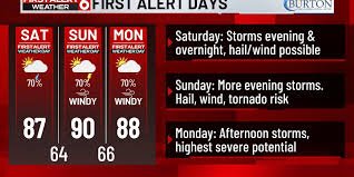
Looking Ahead: The Forecast for Sunday and Monday
Unfortunately, the danger is far from over. We are currently in the middle of a four-day window of severe weather. While Sunday may start with spotty showers, the atmosphere will warm up to near 90°F, creating the perfect fuel for another round of strong evening storms after 6 PM.
The most concerning outlook is for Monday. The National Weather Service has indicated an Enhanced (Level 3) risk for the metro area. This means a higher probability of severe weather, with potential tornadoes expected after 3 PM. Residents are encouraged to keep their weather radios tuned and stay informed via official channels like the National Weather Service (NWS).
Essential Safety Tips for Severe Weather
When dealing with a flood watch or a severe thunderstorm warning, preparation is your best defense. Follow these guidelines to stay safe:
- n
- For Flooding: Never drive through flooded roads. “Turn around, don’t drown.” Move to higher ground immediately if you are in a flood-prone area.
- For High Winds and Hail: Stay indoors and away from windows. Secure outdoor furniture and equipment.
- For Tornadoes: Find a basement or an interior room on the lowest floor of a sturdy building. Avoid mobile homes, as they offer little protection.
For more comprehensive guidelines on weather preparedness, visit the NOAA (National Oceanic and Atmospheric Administration) website.
Stay vigilant, keep your devices charged, and prioritize your safety as these storms move through the heartland.


