
Edmonton Weather Alert: Prepare for a Sudden Chill and Potential Snow this Long Weekend
If you’ve been enjoying the unseasonably mild temperatures across Alberta, it’s time to hold onto that warmth while it lasts. The current trend in Edmonton weather is about to take a sharp turn, shifting from spring-like comfort to a bracing cold snap just in time for the long weekend.
Weather patterns are shifting rapidly, and for those in the capital and surrounding regions, the transition will be nothing short of a shock to the system. Here is everything you need to know to prepare for the coming days.
The Calm Before the Storm: Wednesday’s Outlook
Wednesday marks the final stretch of warmth. Albertans can expect mild temperatures continuing through the day, with highs remaining in the mid-to-upper 20s. However, this warmth comes with a side of instability.
- n
- Thunderstorm Risk: There is an increased chance of rain and thunderstorms, particularly along the foothills and extreme southern Alberta.
- Incoming Rain: Widespread rainfall is expected to develop late Wednesday evening as a low-pressure system strengthens.
The Big Cool Down: Thursday and Friday
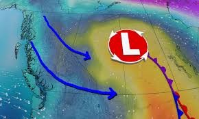
The atmospheric shift begins in earnest on Thursday. A trough in the jet stream over the Pacific is pushing east, ushering in a surface low-pressure system over Alberta that will effectively kill off the warmth.
By Thursday and Friday, temperatures will plummet back to seasonal norms, with highs hovering in the mid-teens. But it’s not just the temperature you need to worry about—wind is a major factor. Expect significant gusts ranging from 70 to 90 km/h on Thursday afternoon, which will make the air feel even chillier.
Long Weekend Forecast: Will it Snow?
For those planning outdoor activities for the long weekend, you might want to have a Plan B. The trend for Edmonton weather and broader Alberta regions suggests a return to winter-like conditions.
As cold air sinks south, we are looking at:
- n
- Single-Digit Highs: Daytime temperatures could drop into the single digits, particularly for Calgary and surrounding areas by Saturday.
- Return of Snow: Rain is expected to transition into snow across northern Alberta starting Friday. With freezing levels dropping to 1600 metres or lower, snow is also highly possible in the Rockies and foothills throughout the weekend.
- Below-Average Temps: Forecasts suggest temperatures could be 5 to 10 degrees below the seasonal average for mid-May.
Staying Safe and Informed
With river levels already running high in northern parts of the province, the predicted heavy rainfall (locally exceeding 30mm in some eastern and northern sections) could increase the risk of localized flooding. Residents are encouraged to stay vigilant.
To stay updated with real-time alerts, we recommend monitoring Environment Canada for official warnings and forecasts.
Bottom line: Dust off your jackets and keep the umbrellas handy. The transition from spring warmth to May snow is a classic Alberta experience, and this weekend looks like it will be a textbook example.


