
Super El Niño Alert: What It Means for US Weather and the Upcoming Hurricane Seasons
The global climate is shifting, and the forecast is pointing toward something massive. Recent data from the Pacific Ocean indicates that we are accelerating toward a Super El Niño—a powerful climate pattern that could drastically reshape weather patterns across the United States and alter the trajectory of this year’s hurricane seasons.
But what exactly is a “Super” El Niño, and why should you care? From potential floods in California to a quieter Atlantic, here is everything you need to know about the impending atmospheric shift.
Understanding the Super El Niño Phenomenon
El Niño is one of the three phases of the El Niño-Southern Oscillation (ENSO), a natural cycle of temperature changes in the central Pacific Ocean. While a standard El Niño occurs when waters warm up, a “Super El Niño” is declared when sea surface temperatures in the Central Pacific reach at least 2 degrees Celsius above average.
According to recent observations, a massive pool of warm water in the Western Pacific is currently “sloshing” eastward. This movement, driven by westerly winds, is expected to fully develop by this summer, potentially making this one of the strongest El Niño events ever recorded.
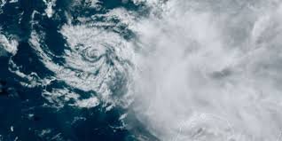
The Tale of Two Oceans: Atlantic vs. Pacific Hurricanes
The impact of a Super El Niño isn’t uniform; it creates a striking contrast between the two major hurricane basins:
- n
- The Atlantic Basin: Typically, El Niño increases upper-level wind shear. This acts as a “shield,” creating a hostile environment that suppresses storm development and reduces the overall number of tropical systems.
- The Eastern Pacific Basin: Conversely, warmer waters act as fuel. The Eastern Pacific hurricane season is expected to be “supercharged,” with sea surface temperatures already 2 to 3 degrees above average, leading to increased tropical activity.
Note: While the Atlantic may see fewer storms, experts from the National Oceanic and Atmospheric Administration (NOAA) remind us that it only takes one major storm to cause catastrophic impact. Preparation is always key.
How Super El Niño Will Affect US Weather and Winter
The influence of El Niño extends far beyond the coastlines. As the pattern strengthens, it begins to “bend” the Pacific jet stream—the atmospheric conveyor belt responsible for transporting storms across the Lower 48 states.
What to expect in the coming months:
- n
- Southern Tier Wetness: The jet stream is forecast to shift southward, likely bringing wetter-than-average conditions to California and the Southern United States.
- Winter Outlook: This shift is expected to persist through the winter months, potentially increasing the risk of flooding and heavy precipitation in the South.
- Coastal Risks: While open-ocean formation in the Atlantic may drop, the European forecast models suggest that tropical activity closer to the U.S. mainland—particularly in the northern Gulf and Southeast coast—could remain near normal.
The Role of AI in Modern Weather Tracking
Predicting these massive shifts is becoming more accurate thanks to technology. Meteorological organizations are now integrating advanced AI tools to track cyclones and model the movement of warm water pools with unprecedented precision. These AI-driven insights allow for better early warning systems, giving communities more time to evacuate and prepare for extreme weather.
Final Thoughts: Stay Informed
Whether it’s a quieter Atlantic or a drenched winter in the South, the Super El Niño is a reminder of the powerful connection between ocean temperatures and our daily lives. To stay safe, we recommend checking your local evacuation zones and staying tuned to high-authority sources like NASA Climate for real-time updates.


