
Central Florida Under Tornado Watch: What You Need to Know to Stay Safe
Residents across Central Florida are on high alert as a tornado watch has been issued for the entire region. While a watch does not mean a tornado has been spotted, it indicates that atmospheric conditions are favorable for their development. If you are in the Orlando metro area or surrounding counties, now is the time to stay vigilant and prepare for potentially severe weather.
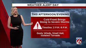
Timing and Expected Storm Path
The current tornado watch is set to expire at 6 p.m., but the risk of severe weather extends further into the evening. A cold front moving through the state is expected to trigger scattered storms between 3 p.m. and 11 p.m.
The storm progression is expected to follow this timeline:
- n
- 1 p.m. to 3 p.m.: Storms move into northern areas, including Marion, northern Volusia, and Flagler counties.
- 4 p.m. to 6 p.m.: Activity shifts toward the I-4 corridor, heavily impacting the Orlando metropolitan area.
- 7 p.m. to 9 p.m.: Heavier activity moves south, affecting Osceola and Brevard counties.
- 10 p.m.: Most major storms are expected to move offshore, leaving behind some lingering rain.
Primary Weather Threats: Wind, Heat, and Fire
While the primary concern is the tornado watch, there are several other weather hazards to keep in mind today:
1. Damaging Winds and Hail
The most significant threat is damaging wind gusts. There is a 5–15% chance of severe winds capable of downing power lines and trees. Although the risk remains low, brief tornadoes and hail cannot be entirely ruled out.
2. High Heat Index
Before the storms arrive, Florida’s summer-like heat will be in full force. With highs reaching the low to mid-90s, a moderate heat risk is in effect. It is crucial to stay hydrated and seek cooling if you are sensitive to extreme temperatures.
3. Red Flag Warning (Fire Danger)
Paradoxically, while some areas face storms, others—especially south of Orlando—are under a Red Flag Warning. Due to low humidity and gusty winds, fire danger is extremely high. Local officials strongly advise against any outdoor burning, as lightning strikes could easily spark uncontrollable wildfires.
How to Prepare and Stay Safe
When a tornado watch is in effect, the best strategy is preparation. Ensure you have a way to receive emergency alerts and identify a safe room in your home (such as an interior closet or bathroom on the lowest floor).
For official safety protocols and real-time updates, we recommend visiting the National Weather Service (NWS) or the NOAA website.
Looking Ahead: A Cooler Sunday
There is a light at the end of the tunnel. Following the passage of the cold front, Central Florida can expect a refreshing shift in temperature. Sunday’s highs will drop to the upper 70s and low 80s, accompanied by a breezy north-northeast wind and plenty of sunshine for northern regions.


