
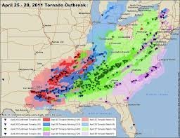
The Fury of Nature: Understanding the Catastrophic 2011 Tornado Super-Outbreak
North America is no stranger to the raw power of nature, particularly during the transition from spring to early summer. While many storm seasons pass with only a few isolated incidents, occasionally, the atmosphere aligns in a perfect, terrifying storm. One of the most devastating examples in history occurred between April 25 and April 28, 2011, an event now known as a “super-outbreak.”
A Record-Breaking Disaster
In a staggering four-day window, a total of 362 tornadoes touched down across the continent. This wasn’t just a fluke of weather; it was a meteorological anomaly that resulted in 324 lives lost and approximately $12 billion in damages. The scale of destruction was unprecedented, marking one of the deadliest series of storms ever recorded.
The Perfect Storm: How do these Monsters Form?
Tornadoes don’t happen in a vacuum. For a super-outbreak to occur, several atmospheric “ingredients” must merge simultaneously. In April 2011, these factors converged over the Southern Plains:
- n
- Moisture: Warm, unstable air was pushed northward from the Gulf of Mexico.
- Lift: A powerful upper-level trough provided the necessary lifting mechanism to trigger supercells.
- Wind Shear: An intense jet stream in the middle troposphere, with speeds reaching 150 to 180 km/h, created strong wind shear, causing storm cells to rotate violently.
The Terror of the EF5 Tornado
Among the hundreds of storms, the most feared were the EF5 tornadoes. On the Enhanced Fujita (EF) Scale, an EF5 is the pinnacle of destruction, with wind speeds exceeding 320 km/h.
Measuring these winds is notoriously difficult because the most accurate instruments—anemometers—are usually destroyed instantly by the storm. Meteorologists now rely on a combination of damage surveys and advanced Doppler radar technology to estimate the wind speeds of these monsters.
The Importance of Early Warning Systems
Despite the devastation, the 2011 outbreak highlighted the critical importance of meteorological forecasting. The Storm Prediction Center (SPC) had issued high-risk alerts days in advance.
With an average warning lead time of about 24 minutes, thousands of people were able to seek shelter in time. This stands in stark contrast to historical disasters, such as the 1936 storms, where the lack of technology meant victims had almost no time to react.
Conclusion: A Lesson in Vigilance
The events of April 2011 serve as a grim reminder of the unpredictability of our atmosphere. While we cannot stop a tornado, the evolution of satellite imaging and radar allows us to anticipate them with increasing precision. Staying informed during the spring season remains the best defense against the wind’s destructive power.



