
Heavy Snow Warning: Which States are Seeing the Best Spring Powder?
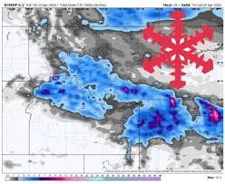
If you are wondering which states are currently under a heavy snow warning or experiencing significant late-season accumulation, the answer lies in the heart of the Mountain West. While spring is typically a time for melting, a potent weather system is currently delivering a fresh dose of winter to Wyoming, Montana, and Idaho.
For skiing and snowboarding enthusiasts, this is the kind of news that sparks an immediate trip. However, the snowfall is not distributed evenly across the region. Here is the detailed breakdown of where the snow is hitting hardest.
The Epicenter: The Tetons and Southwest Montana
Confidence among weather models is highest for the period between Thursday evening, April 23, and Saturday morning, April 25. The primary focus of this storm is the Teton range and the high terrain of southwest Montana.
The following resorts are expected to see the most significant totals:
- Grand Targhee (Wyoming)
- Jackson Hole (Wyoming)
- Big Sky (Montana)
- Bridger Bowl (Montana)
These areas are situated directly in the main snow band, ensuring the highest accumulation rates of the event.
What About Idaho?
While Idaho is part of the broader system, the impact is notably lighter. Operations at Bogus Basin and Tamarack are expected to see only light showers and cold mornings with minimal accumulation. If you’re heading to Idaho, don’t expect a massive reload, but do enjoy the crisp, cold air.
Snow Quality and Technical Details
For those tracking the Snow-to-Liquid Ratio (SLR), the quality is evolving. Early precipitation started as dense to moderate snow (SLR 9-12:1). However, as the system progresses into Friday morning, the snow is becoming lighter and fluffier, with ratios shifting toward 12-15:1.
Warning: Be mindful of the wind. Gusty northwest winds, reaching 30-45 mph on exposed ridges, are creating wind-affected surfaces. For real-time safety updates and official alerts, always check the National Weather Service (NWS).
The Extended Forecast: What Happens Next?
Looking ahead to the weekend and beyond, the intensity will taper off:
- Saturday: A quieter, cold day. Expect firm morning conditions that will soften as the sun breaks through.
- Sunday & Monday: Lower confidence in the forecast, but likely scattered light showers in the Tetons, southwest Montana, and the Idaho Panhandle.
- Next Week: A warmer trend is expected from Tuesday onward. Snow levels will rise, making lower-mountain precipitation more likely to fall as rain rather than snow.
While the broader signal leans warmer for Idaho and western Montana, Wyoming remains the best bet for occasional unsettled weather through the coming week.
Are you hitting the slopes this weekend? Share your experience with us and let us know how the conditions are at your favorite resort!



