
New Jersey residents, prepare for a significant winter event! A potent mix of snow, sleet, and freezing rain is set to descend upon the Garden State, bringing widespread impacts from this afternoon through the weekend. This isn’t just a dusting; forecasters are predicting substantial accumulations, particularly across northern regions of NJ, with challenging travel conditions expected.
The Impending Winter Blast: What to Expect from NJ Weather
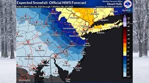
The National Weather Service (NWS) has issued an urgent warning: a formidable winter storm is gearing up to hit New Jersey. Starting this afternoon, a dangerous cocktail of precipitation will sweep across the state. The northern half of NJ is bracing for widespread snowfall totals of 4 to 8 inches, but some higher elevations in northern New Jersey could see up to a foot of snow if intense snow bands materialize. This NJ snow forecast is critical for residents to heed.
Winter storm warnings have been expanded overnight, now encompassing 11 counties predicted to receive the heaviest snow. An additional eight counties are under winter weather advisories, signaling hazardous conditions. These warnings highlight the gravity of the approaching NJ weather system, urging preparedness for potential freezing rain NJ and a significant NJ ice storm threat.
Counties Under Winter Storm Warning:
- Bergen County
- Essex County
- Hudson County
- Middlesex County
- Monmouth County
- Morris County
- Passaic County
- Somerset County
- Sussex County
- Union County
- Warren County
Friday’s Fury: Peak Impacts and Travel Alerts
“Snow develops this afternoon,” stated the NWS in its early Friday update. The highest snowfall accumulation is expected across areas near and north of I-80. As evening progresses, the snow will transition to a treacherous mix of sleet New Jersey and freezing rain for regions south of I-78 and northwest of I-95. This icy blend poses a significant threat, potentially creating a dangerous coating of ice on surfaces.
Snow is anticipated to begin between 1 p.m. and 3 p.m. in northern areas. The most intense period of this New Jersey winter storm is projected for Friday evening, roughly between 7 p.m. and 11 p.m. During this critical window, snowfall rates could surge to 1 to 2 inches per hour within intense snow bands located just south of the New York metropolitan area.
This intense banding will profoundly impact travel, particularly along the New Jersey Turnpike and Interstate 78, making the Friday night rush hour exceptionally hazardous. Commuters are strongly advised to reconsider travel plans and stay updated on local conditions from sources like the New Jersey Department of Transportation. This is a critical travel impact NJ alert.
Regional Snowfall Breakdown: How Much Will Your Area Get?
Snowfall totals will vary considerably across NJ, influenced by elevation and proximity to the heaviest bands. Understanding your specific forecast is key for this NJ storm update.
- Warren and Sussex Counties: Lower elevations may see 4 to 6 inches, while higher terrain could accumulate 8 to 12 inches.
- Northern Somerset, Middlesex, and Monmouth Counties: Expect 5 to 6 inches. However, southern sections of these counties will likely see lower totals as sleet mixes in more readily.
- Counties South of I-195: Prepare for 1 to 5 inches of mixed snow and sleet, with the possibility of an ice glaze forming along and west of the Delaware River.
- Far Southern New Jersey (including Salem and Cumberland Counties): Primarily freezing rain is forecast, with ice accumulations up to 0.05 inches.
- Southern Jersey Shore: Mostly rain is expected here, offering a slight reprieve from the frozen precipitation.
Beyond Friday: The Weekend and Early Next Week Outlook
The storm’s grip will loosen somewhat on Saturday morning, with precipitation tapering off. However, light snow or flurries might linger through midday across some areas of New Jersey. This weekend weather NJ outlook requires continued vigilance.
- Saturday: Temperatures will struggle to reach freezing in northern NJ, while southern regions should see highs climb into the mid to upper 30s.
- Saturday Night: Expect a cold night, with lows plummeting into the teens across northern New Jersey and the low 20s elsewhere.
- Sunday: Starts cold, but temperatures will gradually moderate. A warm front will usher in rain for most areas by Sunday afternoon and evening. Northern NJ could experience a brief period of freezing rain Sunday evening before it transitions to plain rain. Highs on Sunday will range from the low to mid-30s in the northwest to the mid and upper 40s in southern New Jersey.
Looking Ahead to Monday & Tuesday
Rain will persist through Sunday night, with temperatures steadily rising. Monday promises to be rainy, with highs soaring into the 50s, possibly nearing 60 degrees. However, a strong cold front will sweep through Monday afternoon and evening, bringing a dramatic shift. This will be followed by gusty northwest winds developing Monday night and continuing into Tuesday.
On Tuesday, wind gusts could reach a formidable 30 to 40 mph, driving wind chills down into the teens. Bundle up! A weak clipper system might bring additional weather on Wednesday, though significant impacts are not anticipated. Temperatures will moderate slightly on Wednesday before cooler air potentially filters back into the region by Thursday.
Stay Informed and Stay Safe!
This comprehensive NJ weather update underscores the importance of preparation. Keep a close eye on local forecasts and advisories from reliable sources like the National Weather Service (NWS) Mount Holly/Philadelphia office, which covers much of New Jersey, and the New Jersey Office of Emergency Management. Ensure your emergency kits are ready, phones are charged, and travel plans are adjusted to prioritize safety. Drive carefully if you must, and avoid unnecessary travel during the storm’s peak.


