
Dangerous Weather Alert: Large Hail and Violent Tornadoes Siege the US Plains
A perilous weather pattern is currently unfolding across the US Plains and Midwest, bringing a volatile mix of catastrophic tornadoes, destructive winds, and massive hail. Residents from the Central Plains to the Mississippi Valley are urged to remain vigilant as a series of severe thunderstorms move through the region.
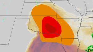
The Immediate Threat: Supercells and Destructive Hail
Meteorologists are closely monitoring the development of supercell thunderstorms. These powerful storm systems, fueled by warm, humid air and intense wind shear, are capable of producing not only strong tornadoes but also very large hail that can cause significant property damage and pose a threat to life.
Key areas on high alert include:
- Kansas, Nebraska, and Missouri: High risk of supercells and damaging wind gusts.
- Oklahoma City and Kansas City: Critical alert levels for sudden storm development.
- Texas (Dallas, San Antonio, Austin): Potential for large hail and high-velocity winds.
Recent Devastation: EF4 Tornadoes and Softball-Sized Hail
The severity of this weather system has already been proven. Recently, a rare tornado emergency was declared for Enid, Oklahoma, where a catastrophic EF4 tornado struck. With wind speeds reaching up to 175 mph, the storm caused extensive damage near the Vance Air Force Base, leaving multiple injuries in its wake.
The hail reports have been equally shocking. In Marion, Kansas, observers reported hail stones measuring 4 inches in diameter—roughly the size of a softball. Such extreme precipitation highlights the volatility of the current atmospheric conditions.
Looking Ahead: The Path of the Storm
As the system progresses, the threat is expected to shift toward the Mississippi and lower Ohio Valleys. By Monday and Tuesday, cities such as St. Louis, Nashville, Indianapolis, and Chicago could face long-track, particularly dangerous tornadoes.
Furthermore, the Gulf Coast states—specifically from northeastern Texas to northwestern Alabama—should monitor conditions closely as a lingering frontal boundary may trigger additional severe activity.
Essential Safety Tips for Severe Weather
When facing severe storms, your safety depends on quick action and reliable information. According to the National Oceanic and Atmospheric Administration (NOAA), staying informed is the first line of defense.
Flash Flood Awareness
With heavy rainfall saturating the ground across the Midwest, flash flooding is a primary concern. Remember these critical rules:
- Turn Around, Don’t Drown: Never attempt to drive through flooded roads, especially at night.
- Seek Higher Ground: If you are in a flood-prone area, move to higher ground immediately.
- Stay Alert: Use multiple methods to receive weather alerts (apps, radio, and sirens).
With over 1,300 reports of severe weather—including hundreds of hail and tornado sightings—this season is proving to be exceptionally aggressive. Stay safe, stay tuned to local forecasts, and prioritize your security over property.


