
Indianapolis Braces for First Major Winter Storm of the Season
Central Indiana residents, prepare for a significant shift in the Indianapolis weather this weekend! The National Weather Service (NWS) has issued the season’s first winter storm watches, effective from late Friday night through Sunday afternoon. This alert signals a substantial winter event across the northern half of Indiana, promising heavy snowfall and challenging conditions.
According to Storm Track 8 Chief Meteorologist Keith Gibson, heavy snow is expected to begin for Indianapolis on Saturday afternoon. As temperatures rise slightly above freezing Saturday night, a mix of rain and snow is anticipated, potentially complicating snow accumulation forecasts.
Anticipated Snowfall Totals Across Indiana
While specific snow totals remain somewhat uncertain, the NWS has provided preliminary accumulation estimates:
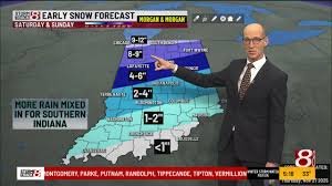
- Central Indiana (including Indianapolis): Expecting 3 to 7 inches of snow. This watch covers numerous counties, including Boone, Carroll, Clay, Clinton, Delaware, Fountain, Hamilton, Hancock, Hendricks, Henry, Howard, Madison, Marion, Montgomery, Parke, Putnam, Randolph, Tippecanoe, Tipton, Vermillion, Vigo, Warren, and Wayne. Higher amounts are currently projected closer to Lafayette.
- Northern Indiana: Accumulations could range from 5 to 12 inches in counties such as Adams, Allen, Blackford, Cass, De Kalb, Elkhart, Fulton, Grant, Huntington, Jay, Kosciusko, La Porte, Lagrange, Marshall, Miami, Noble, Pulaski, St. Joseph, Starke, Steuben, Wabash, Wells, White, and Whitley.
- Northwest Indiana: Over 6 inches of snow is possible for Benton, Jasper, Lake, Newton, and Porter counties.
Stay updated with the latest forecasts directly from the National Weather Service Indianapolis for real-time information as the storm develops.
Travel Warnings and Lingering Cold
The NWS has issued a stark warning: “Travel could be very difficult” during this period, particularly in Central Indiana. Residents are strongly advised to reconsider non-essential travel. Furthermore, even after the storm passes, the cold will persist. Temperatures are not expected to rise above the teens and 20s well into early next week, meaning any freezing precipitation could stick around for an extended period.
Adding to the concern, Meteorologist Keith Gibson suggests the Indianapolis area could see even more snow on Monday, prolonging the wintery conditions.
Indianapolis City’s Snow Removal Plan Put to the Test
This upcoming storm marks the first significant test of the Indianapolis city government’s updated snow removal strategy. Following widespread complaints last January when many streets remained unplowed after 11 inches of snow, the city has revised its policy:
- Residential streets will now be plowed once snow accumulations reach 4 inches or more.
- Streets near schools and township buildings will receive priority plowing when snowfall hits 2 inches.
This new approach aims to address the previous policy’s shortcomings, which excluded approximately 1,400 lane miles of residential streets from plowing efforts. For updates on road conditions and travel advisories, consult the Indiana Department of Transportation (INDOT).
Prepare for the Winter Blast
With a considerable winter storm heading our way, now is the time to prepare. Ensure your vehicle is fueled, emergency kits are stocked, and you have a plan for staying safe and warm indoors. Stay informed about the evolving Indianapolis weather forecast and local advisories to navigate this winter event safely.


