
Severe Weather Alert: Southeast Michigan Under Watch
Southeast Michigan residents, be prepared! A Marginal and Slight Risk (Levels 1 & 2 out of 5) for severe weather is in effect tonight, meaning the possibility of strong storms is real. While the risk isn’t extreme, it’s crucial to stay weather aware and have a plan in place.
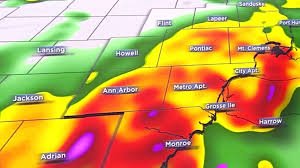
Storms are expected to develop and move into the region around 10 p.m. tonight. Ensure you have reliable methods for receiving alerts throughout the night. This includes utilizing weather apps with notification capabilities, a weather radio, and tuning into local television, radio, or trusted weather websites like the National Weather Service.
Key Threats from Tonight’s Storms
- Damaging Wind Gusts: Winds could reach up to 60 mph.
- Heavy Rainfall: Localized downpours are expected, with potential rainfall totals of 1-2 inches by Wednesday afternoon.
- Large Hail: Hail up to 1 inch in diameter or greater is possible.
- Isolated Tornadoes: While not widespread, the possibility of isolated tornadoes exists.
Freezing Rain Potential in Northern Thumb and Bay Region
For those in the northern Thumb and Bay region, a different threat is emerging: freezing rain. Temperatures will be cold enough to allow for ice accumulation, potentially reaching 0.1 inches by Wednesday morning. This could create hazardous travel conditions.
Looking Ahead: Wednesday and Beyond
The main rain is expected to move out by midday Wednesday as temperatures fall. However, scattered wintry mix is possible Wednesday night into Thursday. Be prepared for significantly colder temperatures, with wind chills in the teens on Thursday morning. The cold weather pattern is expected to persist through the end of the week, with further chances for wintry precipitation.
Stay tuned to 4Warn Weather for the latest updates and safety information. Your safety is our priority.
Source: WDIV ClickOnDetroit
About the Meteorologist: Christina Burkhart is a Saline native with a lifelong passion for weather, sparked by a childhood tornado. She holds degrees from Michigan State and Mississippi State and brings award-winning experience back to Detroit.


