
Ottawa Weather Update: Mild Temperatures Bring Records and Flood Concerns
Southern Ontario, including the Ottawa region, is experiencing a dramatic shift in weather patterns, with record-breaking temperatures and a heightened risk of flooding. Environment Canada has issued special weather statements warning of heavy rainfall, dense fog, and potential flooding across several areas.
Record-Breaking Temperatures in Toronto
Toronto recently shattered a daily high temperature record, reaching a balmy 17.4°C. This surpasses the previous record of 16.7°C set back in 2012, marking the warmest temperature for this date in over a decade, as reported by Global News chief meteorologist Anthony Farnell. This unseasonable warmth is raising questions about the pace of climate change and its observable effects.
A commenter recently questioned the timeline of breaking temperature records in relation to climate change efforts, noting the 13-year gap between the previous record and the current one. This highlights a complex issue and the need for continued analysis of climate trends.
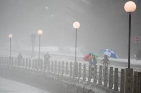
Rainfall and Flood Risks
Between 15 and 40 mm of rain is forecast for some regions, with localized areas potentially receiving even higher amounts due to thunderstorms. This rainfall, combined with the mild temperatures, is accelerating the melting of the substantial snowpack accumulated during this winter’s extreme weather. The rapid snowmelt, coupled with frozen ground limiting water absorption, significantly increases runoff and the risk of flooding, particularly in low-lying areas.
Important Safety Reminders:
- Avoid driving through flooded roads.
- Be cautious of potential washouts near rivers and creeks.
- Monitor alerts and forecasts issued by Environment Canada.
- Consult your local conservation authority or the Ontario Ministry of Natural Resources for more information on flooding.
Fog Advisory
In areas northwest of Toronto, near-zero visibility due to dense fog is also a concern. While the fog is expected to dissipate later in the day as winds shift, travel could be hazardous with sudden reductions in visibility.
Forecast Outlook
The warm stretch is expected to continue into Wednesday, with sunshine anticipated on Monday and temperatures ranging from 10-17°C. Southern Ontario can expect several rounds of showers and isolated thunderstorms to continue through Saturday evening. Stay informed about the latest Ottawa weather updates.
–with files from the Canadian Press


