
Heavy Snow Warning: Pacific Northwest Braces for Multiple Storms
SEATTLE – The Pacific Northwest is preparing for a series of storm systems this week, bringing a mix of colder temperatures, strong winds, periods of rain, and significant snowfall in the mountains. The most impactful weather is anticipated on Wednesday, with heavier rainfall, increased wind speeds, and continued heavy snow accumulation in the Cascade range. Stay informed and prepared with the latest updates from KING 5.
Current Conditions & Forecast
A cold front moved through Western Washington on Sunday, ushering in widespread rain. As temperatures drop, snow levels are expected to descend to around 3,000 feet. A convergence zone impacting King and Snohomish counties may linger into Monday morning, potentially bringing localized heavy showers and substantial snowfall to Stevens Pass.
Weather Alerts in Effect
Weather alerts have already been issued for the Cascade Mountains due to the expectation of significant snowfall. The unsettled weather pattern is forecast to continue through Monday and Tuesday, with colder air increasing the possibility of a rain-snow mix in lower elevations, particularly during overnight and early morning hours. Overnight temperatures are predicted to hover near freezing, while daytime highs are expected to reach the 40s.
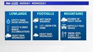
Potential Snow Accumulation
- Mountains: Significant snowfall expected, with snow levels fluctuating between 2,500 and 3,000 feet on Wednesday.
- Lowlands: While major disruptions are not currently anticipated, minor impacts are possible in foothill areas. Brief periods of rain and snow mix or wet snow are possible.
Powerful System Arriving Tuesday Night
A more potent storm system is expected to arrive Tuesday night and continue into Wednesday, representing the most significant weather event of the week. A Winter Storm Watch is likely to be issued from late Tuesday night through Friday morning.
KING 5 First Alert
KING 5 has activated its First Alert system for this weather event, recognizing its potential to impact lives, property, and travel throughout the Pacific Northwest. The First Alert Weather Team is dedicated to providing you with the latest information to ensure your safety and that of your family. You can download the KING 5 app to receive real-time alerts and updates.
Impacts & Safety Precautions
In lowland areas, rainfall is expected to increase and may become heavy at times, especially on Wednesday. Wind gusts between 30 and 40 mph are possible, potentially making commutes more challenging. Travelers, particularly those navigating mountain passes, should prepare for winter driving conditions and closely monitor the latest forecasts throughout the week. For safe winter driving tips, visit the National Highway Traffic Safety Administration.
Precipitation Totals (Through Friday)
The region could experience significant precipitation totals through Friday. Forecast details are subject to change, so please check back for updates.
Stay tuned to KING 5 for the latest updates and safety information.


