
Yellow Warning: Freezing Rain Expected in Toronto
Toronto and parts of the Greater Toronto Area (GTA) are under a yellow freezing rain warning as mixed precipitation is anticipated throughout the day. Environment Canada has issued the alert, forecasting periods of light rain and mixing as temperatures hover around the freezing mark.
Icy Conditions Expected
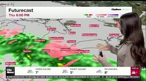
Starting this evening, the rain is expected to transition to freezing rain, potentially leading to hazardous icy conditions and ice accumulation of up to two millimetres. This could create slick roads and sidewalks, making travel dangerous. The highest risk period is expected to be late Thursday into early Friday, with continued chances of precipitation.
Current Forecast & Weekend Outlook
The current forecast predicts a high near 2°C today, with rain and snow continuing into tonight. The freezing rain warning is anticipated to end near midnight. Friday will be mostly cloudy with occasional sunny breaks, but the unsettled weather pattern will persist. More showers are expected late Friday as another system moves through. The high on Friday will reach 5°C, with a low of 3°C.
A Warm Weekend Ahead…With a Catch
Saturday is shaping up to be the warmest day in the forecast, according to 680 NewsRadio weather specialist Denise Andreacchi, and potentially one of the warmest days Toronto has seen in months. Temperatures are expected to climb to a pleasant 16°C, well above seasonal norms. However, this warmth comes with a tradeoff: scattered showers and strong southwest winds of 20–40 km/h will make for a blustery day.
Looking Ahead: A Return to Cooler Temperatures
The weekend will conclude on a calmer note. Sunday will bring a mix of sun and cloud with a high near 11°C, offering a brief respite before another round of spring-like systems arrives next week. Despite this preview of spring, Andreacchi cautions that the warmth won’t last. Forecasters anticipate a significant temperature drop after March 11th, which is currently projected to be the last day with double-digit temperatures before colder air returns.
Wet March So Far
Southern Ontario is expected to experience numerous weather systems over the next week, each bringing its own round of rain or mixed precipitation. Thursday’s showers, Saturday’s scattered rain, and a mid-week system next week all contribute to what is shaping up to be one of the wettest stretches of March so far. While rain in early March isn’t unusual, the amount can vary significantly from year to year.
Toronto’s long-term climate records indicate that March typically brings a mix of rain and snow, with average monthly precipitation ranging from 65–80 mm. Environment Canada’s historical climate portal provides detailed records dating back decades. According to a Toronto weather dashboard, 65.6 mm of total precipitation was recorded in March 2025, suggesting that the forecast of 10–15 mm for Thursday is within historical norms.
March temperature tables from 2010–2024 confirm that double-digit highs are common in most years, sometimes occurring repeatedly and occasionally reaching the mid-teens. Andreacchi notes that the forecasted highs of 10–14°C this weekend are within the historical pattern – warm, but not unprecedented.
Stay informed with the latest forecasts: Sign up for the CityNews Weather Guarantee and check out Toronto’s extended forecast.
Other News
- Ford government appoints supervisors at two more GTA school boards
- Montreal police arrest Canada’s most-wanted fugitive
- OPP charges man after threat against Premier Doug Ford


