
A rapidly developing snowstorm is currently sweeping across Ontario, causing significant travel disruptions and prompting snowfall warnings for several regions, including Toronto. The storm, originating in northern Ontario, is making its way south, impacting commutes and daily life.
Northern Ontario Road Closures
The Ontario Provincial Police (OPP) have closed over 500 kilometers of highway northeast of Thunder Bay due to hazardous winter conditions. Lake Superior’s north shore is bracing for substantial snowfall, with accumulations expected to reach 15 to 25 centimeters, and potentially even higher in localized areas. This closure highlights the severity of the storm and the importance of avoiding travel in affected regions.
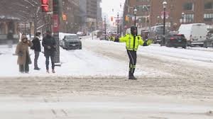
Toronto and Southern Ontario Snowfall Forecast
The Greater Toronto Area (GTA) is under a special weather statement issued by Environment Canada. Residents can expect 5 to 10 centimeters of snow tonight and overnight, with higher accumulations possible further north. This snowfall is expected to make the Wednesday morning commute particularly challenging. It’s crucial to allow extra time for travel and exercise caution on the roads.
Beyond Toronto, areas around Owen Sound and along Lake Huron are anticipating a double whammy of winter weather. Following the current snowfall, further snow squalls are expected to develop tomorrow, potentially exacerbating travel difficulties.
Staying Updated on Toronto Weather
For the latest updates on the Toronto weather and snowfall conditions, refer to these reliable sources:
- Environment Canada: https://weather.gc.ca/ – Provides official weather forecasts and warnings.
- Global News Weather: https://globalnews.ca/weather/ – Offers local weather updates and news coverage.
- The Weather Network: https://www.theweathernetwork.com/ – Delivers detailed weather information and long-range forecasts.
Remember to check these sources frequently for the most up-to-date information and adjust your travel plans accordingly. Safety should be your top priority during this winter storm.


