New York Snowstorm: State of Emergency Declared as Blizzard Conditions Loom
A major winter storm, dubbed a ‘bomb cyclone,’ is currently unleashing its fury on the Eastern United States, with significant impacts expected to extend into Quebec, particularly in Gaspésie and the Magdalen Islands. Here’s a detailed breakdown of what you need to know.
Impacts Across the Region
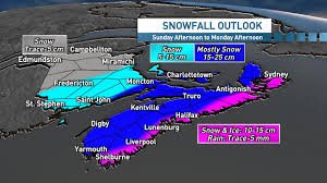
- Gaspésie, Quebec: Up to 15 cm of snow, with wind gusts reaching 60 km/h.
- Magdalen Islands, Quebec: Up to 20 cm of snow, with wind gusts up to 90 km/h.
- New York City: A state of emergency has been declared, and all non-essential travel is prohibited. Over 40 cm of snow is possible, with some areas potentially seeing up to 60 cm. Reports are already coming in of trees falling on vehicles in Brooklyn.
- Boston: Potential for over 60 cm of snow, with wind gusts exceeding 100 km/h, creating blizzard conditions and zero visibility.
- Nova Scotia: Anticipating 30 to 40 cm of snow, with wind gusts up to 90 km/h.
As of Monday morning, over 250,000 homes were without power, and that number is expected to rise. More than 3,000 flights were cancelled on Sunday, with over 10,000 cancellations already reported for Monday.
What is a Bomb Cyclone?
This powerful storm is a “nor’easter” that rapidly intensified along the North American East Coast. This rapid intensification, characteristic of a bomb cyclone, transforms a typical winter system into a powerful snow and wind machine, causing major disruptions to transportation and daily life. It’s fueled by a stark contrast in air masses and the energy of the Atlantic Ocean. This is one of the most significant storms to hit the coast in recent years, stretching from Virginia to Maine.
Quebec Preparedness
While the heart of the storm is focused on the Maritime provinces, Eastern Quebec will also experience significant impacts. The Gaspésie region is expected to be hit Monday afternoon, with the Magdalen Islands receiving the heaviest snowfall. While not a storm for the ages in Quebec, it will undoubtedly complicate travel plans.
Strong winds will accompany the snowfall. Gaspésie can expect gusts of 50-60 km/h Monday afternoon and evening, while the Magdalen Islands could see gusts up to 90 km/h. The combination of snow and wind will likely cause blowing snow and reduced visibility, particularly in exposed areas and along the coast, lasting until Tuesday morning.
Stay Safe and Prepared
Even though Quebec is avoiding the worst of the storm, it’s a good reminder that winter isn’t over yet. Don’t pack away your snow shovel just yet! Be prepared for challenging conditions and exercise caution when travelling. Stay informed about the latest weather updates from reliable sources like The Weather Network and Environment Canada.
With contributions from Bertin Ossonon and Alexandra Giroux, meteorologists.
Source: The most trusted weather information source for Quebecers and Canadians* *According to the 2026 BrandSparkMD Canadian Trust Study and the 2025 Pollara Media Trust Study