
Rhode Island State of Emergency: Blizzard Warning Issued as Nor’easter Approaches
Providence, RI – A State of Emergency has been declared for Rhode Island as a powerful nor’easter is poised to unleash crippling snow and damaging wind gusts across the region. The Storm Team 10 Weather Alert is in effect, with a Blizzard Warning issued for all of Rhode Island and eastern Massachusetts from Sunday evening through Tuesday morning.
Blizzard Conditions Expected
This isn’t just a typical winter storm; blizzard conditions are highly likely. Heavy snowfall combined with powerful northeast wind gusts of 50-70 mph will create near-zero visibility and make travel nearly impossible. The combination of heavy, wet snow and strong winds poses a significant threat to infrastructure and public safety.
Timing of the Storm
The leading edge of the snow will begin to impact Southern New England between 6 PM and 9 PM on Sunday. Moderate snowfall will quickly intensify overnight. Snowfall rates are expected to peak between midnight Sunday and Monday morning, potentially reaching 2-4 inches per hour. By 7 AM Monday, accumulations could approach a foot in some areas.
- Sunday Evening (6 PM – 9 PM): Snow begins to move into the region.
- Sunday Night – Monday Morning: Intense snowfall rates of 1-2+ inches per hour.
- Monday Afternoon (3 PM): Snowfall rates begin to decrease.
- Monday Evening (11 PM): Light to moderate snow may linger.
Wind and Power Outages
The wind will be a major factor in this storm. Gusts of 50-70 mph are anticipated from midnight until noon on Monday, causing blowing and drifting snow, further reducing visibility. These conditions will make travel treacherous and significantly increase the risk of power outages, particularly along the south coastline. The weight of the wet, heavy snow also increases the likelihood of downed tree limbs and power lines.
Prepare for potential, widespread power outages. Have a plan in place and ensure you have necessary supplies.
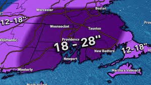
Snowfall Totals
The snowfall forecast has been increasing as the nor’easter’s track is expected to be near the “benchmark” for a significant snowfall event. Widespread accumulations of 18 to 28 inches are expected across most of Rhode Island and southeastern Massachusetts. The immediate south coast and areas towards the Cape Cod canal may see 12 to 18 inches. This storm has the potential to be a top 5 snowstorm for Providence.
Travel Advisory
Travel is strongly discouraged. Road conditions will deteriorate rapidly Sunday night and could become impassable by Monday morning. The combination of heavy snow and strong winds will create zero visibility conditions, making travel extremely dangerous. Expect major disruptions to travel plans.
Stay tuned to Storm Team 10 for the latest updates and information on this evolving weather situation. You can find more information on their website: WJAR.
Source: 2026 Sinclair, Inc.


