
Blizzard Warning: Minnesota Hit Hard by Winter Storm
Minnesota residents experienced a fleeting glimpse of spring over the weekend, but the respite was short-lived. A significant snowstorm descended upon parts of the Twin Cities and northern Minnesota on Wednesday afternoon, bringing hazardous conditions and widespread disruption. The storm prompted a blizzard warning across several counties, urging residents to stay off the roads.
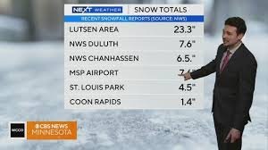
Snowfall Totals and Impact
Northern Minnesota bore the brunt of the storm. As reported by NEXT Weather Meteorologist Chris Shaffer, Grand Marais recorded 15.6 inches of snow, Two Harbors saw 18 inches, and Hovland was blanketed with a staggering 34 inches by midnight. The snowfall intensified throughout Wednesday, creating treacherous conditions for the evening commute.
The impact on travel was substantial. The Minnesota State Patrol reported approximately 220 vehicle crashes statewide between 5 p.m. Wednesday and 10:30 a.m. Thursday, tragically including one fatality. Sixteen crashes resulted in injuries, and another 188 vehicles left the roadway. Thirteen semi-trucks were reported jackknifed, further exacerbating travel difficulties.
Twin Cities Area Snowfall
While northern Minnesota experienced the heaviest snowfall, the Twin Cities area also saw significant accumulation. Chanhassen reported 6.5 inches, St. Louis Park received 4.5 inches, and Coon Rapids saw 1.4 inches. WCCO’s Weather Watcher Network reported 7.5 inches in Edina, 6.5 inches in Mound, and 6.3 inches in Excelsior. Snowfall varied across the region, with Owatonna receiving 2.5 inches and Lino Lakes seeing only half an inch.
School Closures and Snow Emergency
The severe weather led to widespread school closures and delays across the state. The city of St. Paul declared a snow emergency, implementing parking restrictions to facilitate snow removal operations. Residents are urged to adhere to these regulations to ensure efficient cleanup.
Looking Ahead
While lingering light flurries are expected to taper off throughout the day, another weather system is forecast to move through in the evening. This system is primarily focused on southeastern Minnesota and western Wisconsin and is expected to largely bypass the Twin Cities metro area. However, residents should remain vigilant and monitor weather updates.
For the latest weather information and road conditions, please visit the National Weather Service website and the Minnesota Department of Transportation.
Stay safe and be prepared during this blizzard warning!


