Tomorrow’s Weather Forecast: Record-Breaking Typhoon Cempaka Shakes the Northwest Pacific
Tomorrow’s Weather Forecast: Record-Breaking Typhoon Cempaka Shakes the Northwest Pacific
When checking tomorrow’s weather, most of us look for rain or sunshine. However, the Northwest Pacific is currently witnessing a far more intense atmospheric phenomenon. As we approach the winter season in November, the region is grappling with an unusually high number of tropical cyclones, marking a significant shift in seasonal weather patterns.
A Record-Breaking Typhoon Season
According to recent data from the Meteorological Administration, the 32nd typhoon of the year, Cempaka, has officially formed in the waters northwest of Guam. This is not just another storm; it is part of a historic trend. While the Northwest Pacific typically sees an average of 25 typhoons per year, this year has already reached 32, setting a new record since 1994.
Experts suggest that the primary driver behind this surge is the strong influence of El Niño, which has altered sea surface temperatures and atmospheric conditions, creating a breeding ground for more frequent and intense storms.
Tracking Typhoon Cempaka: The Predicted Path
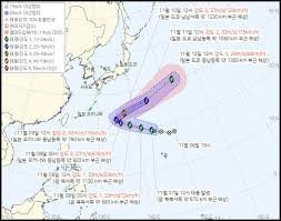
Typhoon Cempaka is expected to move northward toward the open waters east of Okinawa, Japan. Due to high sea surface temperatures and favorable atmospheric conditions, the storm is predicted to intensify significantly.
Here is the detailed projected timeline for Cempaka:
- n
- November 8th: Located approximately 940km north-northwest of Guam with maximum wind speeds of 21m/s.
- November 9th: Moving toward the east-southeast of Okinawa, strengthening to 29m/s.
- November 10th (Peak Intensity): Expected to reach its maximum strength east-southeast of Okinawa, with maximum wind speeds hitting 35m/s (approx. 126 km/h) and a central pressure of 970hPa.
- November 11th – 12th: The storm is expected to slow down near Okinawa before curving northeast toward the distant waters south of Tokyo, eventually weakening as it moves further away.
Will it Affect Korea?
For those monitoring the weather in the Korean Peninsula, there is a sigh of relief. The Meteorological Administration has stated that Typhoon Cempaka is expected to remain far from the peninsula and is unlikely to have any direct impact on the region.
Understanding the Global Impact
The occurrence of such strong typhoons late in the year is a reminder of the volatility of our global climate. To understand more about how these patterns work, you can explore the World Meteorological Organization (WMO), which provides comprehensive data on global weather trends and climate change.
While Cempaka may not hit every coastline, the record-breaking nature of this season serves as a critical warning about the increasing unpredictability of our environment. Stay tuned to official weather channels for the most accurate updates on tomorrow’s weather and beyond.
📰 You May Also Like