
Denver Weather: Major Winter Storm Impacts Colorado
DENVER – A powerful winter storm is currently impacting Colorado, bringing a mix of hazardous conditions across the state. From heavy snowfall in the mountains to near-record heat and high fire danger on the plains, residents are urged to stay informed and prepared. The 9NEWS Weather Impact Team has issued a Weather Impact Alert as an atmospheric river system settles over Colorado.
Mountain Impacts: Snow Squalls & Extreme Winds
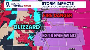
The mountains are facing the brunt of the storm, with blinding snow squalls and extreme winds between 60 and 85 mph. These conditions are expected to continue into Wednesday. This is shaping up to be Colorado’s biggest mountain snow event of the season, lasting from Tuesday night through Saturday morning, with three distinct waves of snowfall. Isolated impacts will continue into Wednesday, followed by another wave on Thursday.
A Winter Storm Warning is in effect until 5 a.m. Thursday morning for Archuleta, Delta, Dolores, Eagle, Garfield, Gunnison, Hinsdale, La Plata, Moffat, Montezuma, Ouray, Pitkin, Rio Blanco, Routt, San Juan & San Miguel counties. The 9NEWS Weather Impact Team forecasts 3-20 inches of snow across Colorado’s mountains from Tuesday morning to Wednesday night, with potential for up to a foot of snow on high mountain passes and peaks.
Travel in the mountains will be extremely difficult, if not impossible, particularly Tuesday morning. Snow squalls and wind gusts up to 70 mph will create zero-visibility blizzard conditions. Driving is strongly discouraged between 4 and 10 a.m. due to the combination of snow and wind.
Front Range & Denver Metro Area: Wind & Fire Danger
The Denver metro area and Front Range will experience lesser impacts, but residents should be aware of frequent 30-50 mph wind gusts on Tuesday, elevating the risk of grass fires. Stronger winds are anticipated in areas surrounding the Front Range, with potential gusts up to 60 mph in the foothills, the base of the foothills, the Palmer Divide, and the northeast plains.
The most extreme winds will be to the south, where the Sangre de Cristo Range could see gusts nearing 85 mph, potentially spilling onto the southeast plains. Residents in these areas should take extra precautions to secure outdoor objects and be prepared for power outages.
Denver International Airport: Flight Delays
Hundreds of flights at Denver International Airport (DIA) have been delayed on Tuesday due to the strong winds impacting Colorado’s Front Range. Travelers are advised to check their flight status before heading to the airport. You can find the latest flight information on the DIA website.
Stay tuned to 9NEWS for the latest updates on this developing weather situation. We will continue to provide comprehensive coverage and keep you informed.
Resources:


