
Baltimore Weather Alert: Preparing for a Wet and Chilly Stretch
If you are in the Maryland area, it is time to grab your umbrellas and heavy coats. The Baltimore weather is taking a turn for the cooler, with persistent rain and brisk winds expected to impact the region over the next few days.
What to Expect Tonight
Rain is currently moving through the Baltimore metropolitan area. While the precipitation is steady, the good news is that no lightning strikes have been reported, reducing the immediate risk of severe thunderstorms. However, don’t let your guard down—while the rain may taper off briefly this evening, it is expected to pick up again overnight.
Tuesday’s Forecast: Cold and Damp
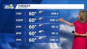
Tuesday is shaping up to be a challenging day for commuters and outdoor enthusiasts. The Baltimore weather forecast predicts continued periods of rain, accompanied by a significant drop in temperature.
- n
- High Temperature: Expect highs to hover only around 60°F (approx. 15°C).
- Wind Conditions: A brisk wind coming from the east at 10-15 mph will make the air feel considerably colder than the thermometer suggests.
- Atmosphere: Expect damp, gray conditions throughout the day.
How to Stay Safe and Informed
Weather patterns can shift quickly. To ensure you are always up to date with real-time alerts and radar imagery, we recommend following official channels. You can check the National Weather Service for high-authority meteorological data and warnings.
Additionally, staying connected via mobile apps is the best way to receive push notifications regarding “Impact Days” or “Alert Days” that could affect your daily travel or safety.
Quick Tips for the Coming Days:
- n
- Dress in Layers: With the wind chill, layering is key to staying warm.
- Check the Radar: Keep an eye on local radar before heading out to avoid the heaviest downpours.
- Drive Carefully: Wet roads and wind can create hazardous driving conditions.
Stay warm, stay dry, and keep an eye on the sky!



