
More Than Just a Tool: The Power of Cartography
For most of us, a world map is simply a tool for geolocation or a classroom decoration. However, as geography experts argue, a map is far more than a drawing—it is a powerful instrument of influence that shapes our subconscious perception of the world. For centuries, the way we viewed our planet was skewed, not by accident, but by the mathematical limitations and political motivations of the time.
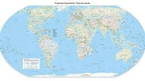
In a landmark move, the United Nations General Assembly recently adopted a resolution to promote a new edition of the world map: the Equal Earth projection. This shift aims to provide a more accurate representation of continental sizes, challenging the long-standing dominance of the Mercator projection.
The Mercator Problem: A Legacy of Distortion
Since the 16th century, the Mercator projection has been the global standard. While it was revolutionary for nautical navigation—because its straight lines allowed sailors to plot courses easily—it came with a significant cost: geographic distortion.
The Mercator map stretches landmasses as they approach the poles. This results in a skewed reality where:
- The Global North (North America, Europe, and Russia) appears disproportionately large.
- The Global South (Africa, South America, and Southeast Asia) appears significantly smaller than it actually is.
According to geography professors, this is not just a technical error; it is a political one. By inflating the size of Western powers and shrinking colonized regions, the map inadvertently reinforced a narrative of Northern dominance and power.
Enter the Equal Earth Projection
The Equal Earth projection represents a pivotal change. Supported by the African Union and Togo, and adopted by 164 UN member states, this model ensures that continents are shown in their true size relative to one another.
For example, when comparing the two, the massive scale of the African continent becomes evident, dwarfing regions like Canada or Greenland, which are exaggerated in the Mercator version. By correcting these proportions, the Equal Earth map allows nations in the Global South to reclaim their narrative and presence on the global stage.
Soft Power and the War of Names
Cartography isn’t just about size; it’s about toponymy—the naming of places. The act of naming a geographic feature is a classic exercise in soft power. Whether it’s renaming gulfs or lakes to reflect national influence, changing a map’s labels is often a strategic move to signal strength and sovereignty.
This geopolitical game extends to how maps are centred. Most maps we use are Eurocentric. However, if Canada were placed at the centre of the map, Canadians would gain a new awareness of their immediate proximity to Russia and the vastness of the Pacific Ocean, fundamentally altering their strategic worldview.
The Challenges of a Global Update
While the shift toward a more balanced map is a victory for geographical accuracy, the transition won’t happen overnight. Experts point to several hurdles:
- Economic Cost: Replacing every textbook, atlas, and digital map globally is a massive financial undertaking.
- Mental Habit: We are conditioned to see the world through the Mercator lens; unlearning this requires a systemic change in primary and secondary education.
Despite these challenges, the move toward the Equal Earth projection is a step toward a more equitable and honest representation of our home. By changing the map, we aren’t just changing lines on a page—we are changing how we perceive human importance and global power.
To learn more about how maps shape our understanding of the world, explore the resources at the National Geographic Society.



