
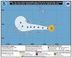
Pacific Storm Surge: Hurricane Lowell Rapidly Intensifies Near Hawaii
The Pacific Ocean is currently a hotbed of activity, and for residents of the Hawaiian Islands, the situation requires close attention. Hurricane Lowell has undergone rapid intensification, skyrocketing from a tropical storm to a powerful Category 4 major hurricane in just 24 hours. With maximum sustained winds reaching a devastating 145 mph, this system is now a primary focus for meteorologists and local authorities.
The Path of Hurricane Lowell: What You Need to Know
As of the latest reports from the National Hurricane Center (NHC), Hurricane Lowell is moving west and is expected to pass approximately 300 miles south of the Hawaiian Islands between Wednesday and Friday. While the center of the storm is projected to remain offshore, its sheer size and strength mean Hawaii will not be entirely untouched.
Forecasters are particularly concerned about the weekend outlook. An upper-level trough approaching from the west could weaken the current steering ridge, potentially causing Lowell to slow down and take a more northward turn. This uncertainty makes continuous monitoring essential for everyone in the region.
Multiple Threats: Hurricane Karina and Tropical Storm Marie
Lowell isn’t the only system stirring the Pacific. The region is currently dealing with a rare trio of tropical threats:
- n
- Hurricane Karina: Also a Category 4 storm with 145 mph winds, Karina is located further east. While it is expected to weaken and pass north of the islands, it adds to the general atmospheric instability of the region.
- Tropical Storm Marie: Currently off the coast of Mexico, Marie is expected to strengthen into a hurricane. While it poses no direct threat to land at this time, it highlights the peak intensity of the current hurricane season.
Expected Impacts on the Hawaiian Islands
Even if a direct hit is avoided, the “indirect” effects of a Category 4 storm can be dangerous. Residents should prepare for the following conditions:
- Dangerous Surf: Life-threatening swells and strong rip currents are expected along the south and east shores.
- High Winds: Gusty tradewinds could reach up to 55 mph, particularly impacting windward and mauka areas.
- Increased Rainfall: Numerous trade showers are expected, which could lead to localized flooding in mountainous regions.
Emergency Preparedness: Stay Safe and Ready
Honolulu Mayor Rick Blangiardi has urged all residents to treat this as a wake-up call to review their emergency plans. With three active systems in the Pacific, being prepared is the best defense.
Your Emergency Checklist:
- Power Backup: Check that flashlights, batteries, and portable power banks are fully charged and functional.
- Communication: Review your family’s emergency contact plan and ensure everyone knows where to meet.
- Supplies: Replenish your emergency kit with non-perishable food, clean water, and essential medications.
- Alerts: Sign up for local emergency alerts (such as HNL Alert) to receive real-time updates.
For the most accurate and up-to-the-minute tracking, keep a close eye on the Central Pacific Hurricane Center (CPHC). Stay safe, stay informed, and remain vigilant as the storm progresses.



