
Stay Alert: Severe Thunderstorm Warnings Impacting the Philadelphia Region
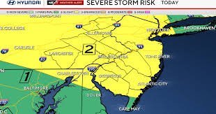
Residents across the Philadelphia region and the Delaware Valley are on high alert as volatile weather patterns sweep through the area. While a previous tornado warning for Burlington County, New Jersey, has been canceled, the threat is far from over. A severe thunderstorm warning remains in effect for several parts of the region, bringing a cocktail of dangerous weather conditions.
Meteorologists warn that these storms are capable of producing heavy rainfall, damaging wind gusts, frequent lightning, and hail. While the immediate tornado threat has diminished in some areas, the possibility of isolated tornadoes remains a concern, urging citizens to stay vigilant and keep a close eye on local weather updates.
Understanding the Weather Pattern: Why the Instability?
The current instability is driven by a large ridge of high pressure situated to the south. This atmospheric setup is causing storms to form daily, generally tracking from the northwest to the southeast. Because of these conditions, the atmosphere remains primed for severe weather, particularly during the afternoon and evening hours.
For those hoping to turn off their air conditioning, it may be too soon. The combination of high humidity and oppressive heat will persist through the middle of the week, making the air conditioning a necessity for several more days.
Looking Ahead: When Will the Weather Break?
There is light at the end of the tunnel. A strong cold front is expected to migrate across the region by Thursday. While this front may initially push the threat of severe weather further south—still impacting Philadelphia and surrounding areas—it will eventually pave the way for a much calmer atmosphere.
By Friday, the unsettled pattern is expected to break down, leading into a beautiful first weekend of September. Expect lower humidity and pleasant highs near 80 degrees under partly cloudy skies.
Quick Look: 7-Day Temperature Forecast
- Tuesday: ⛈️ Storms & Heat | High: 92°F
- Wednesday: ⛈️ Storm Alerts | High: 84°F | Low: 73°F
- Thursday: ⛈️ Storms & Heat | High: 90°F | Low: 72°F
- Friday: 🌦️ Scattered Showers | High: 87°F | Low: 73°F
- Saturday: ⛅ Partly Cloudy | High: 82°F | Low: 68°F
- Sunday: ☀️ Mostly Sunny | High: 79°F | Low: 65°F
- Monday: ☀️ Mostly Sunny | High: 80°F | Low: 61°F
How to Stay Safe During Severe Storms
When a severe thunderstorm warning is issued, taking immediate action can save lives. According to the National Weather Service (NWS), you should:
- Move indoors: Seek shelter in a sturdy building immediately.
- Avoid water: Stay away from swimming pools, lakes, and showers during lightning storms.
- Stay informed: Use a NOAA weather radio or a trusted weather app for real-time alerts.
- Secure outdoor items: Bring in patio furniture or trash cans that could become projectiles in high winds.
Stay tuned for further updates as the NEXT Weather team continues to monitor atmospheric conditions to keep the Delaware Valley safe and informed.



