
Atlantic Alert: NOAA Hurricane Center Monitors Tropical Activity
As we approach the heart of the Atlantic hurricane season, the NOAA Hurricane Center is closely monitoring two distinct areas of interest. While the start of the 2026 season has been relatively quiet, meteorologists warn that we are entering the most volatile window of the year, where tropical systems can develop and intensify rapidly.
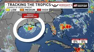
Tropical Depression Five: Potential for New Storm Development
The most immediate concern is Tropical Depression Five, which formed on Monday afternoon with sustained winds of 35 mph. According to the latest forecasts, this system is expected to strengthen quickly, with a high probability of becoming a named Tropical Storm—potentially claiming the name Edouard.
Regardless of whether it reaches tropical storm status, the impact will be felt on land. Residents along the Texas and Louisiana Gulf Coast should prepare for locally heavy rainfall. While the exact path of the moisture remains uncertain, staying tuned to official updates is critical for coastal safety.
Remnants of Tropical Storm Dolly: What South Florida Needs to Know
Meanwhile, the remnants of Tropical Storm Dolly continue to move across the Atlantic. Currently, these remnants are triggering showers and thunderstorms from Hispaniola toward the northern Leeward Islands.
- n
- Redevelopment Chance: The NOAA Hurricane Center gives this system a near-zero chance of reforming into a storm over the next 2 to 7 days.
- Atmospheric Conditions: Strong upper-level winds are currently inhibiting growth as the system moves west-northwest at 20 to 25 mph.
- Impact on Florida: Although it likely won’t re-form, the moisture from Dolly could merge with existing weather patterns, reinforcing a very wet forecast for South Florida later this week.
2026 Season Outlook: Entering the Historical Peak
The Atlantic hurricane season typically hits its peak around September 10th. The period from mid-August through mid-October is historically the most active, driven by the warmest ocean temperatures and favorable atmospheric conditions.
So far in 2026, we have seen four named storms—Arthur, Bertha, Cristobal, and Dolly—but notably, no hurricanes have formed yet. Statistically, the season is running slightly behind the average, which usually sees about six named storms by the end of August.
Expert Warning: A quiet start does not guarantee a quiet finish. It only takes one major landfall to define a season as devastating, regardless of the overall number of storms.
To stay safe and informed, always refer to the official National Hurricane Center (NHC) for real-time tracking and emergency alerts.



