
Tropical Storm Dolly Watch: Will Florida Feel the Impact?
As we enter the most volatile window of the Atlantic hurricane season, residents across the coast are keeping a close watch on the horizon. The latest reports from the National Hurricane Center (NHC) indicate that the Atlantic is currently a breeding ground for potential activity, with several systems under surveillance.
The Rise of Invest 95L and the Potential for Tropical Storm Dolly
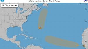
All eyes are currently on Invest 95L, a broad area of low pressure situated a few hundred miles east-southeast of Bermuda. Forecasters suggest that this system is showing signs of organization and could strengthen into a tropical depression or a named storm—which would be Tropical Storm Dolly—within the next few days.
While the current trajectory suggests the system will move northward and north-northeastward, remaining well clear of Bermuda, the unpredictability of the Atlantic means constant monitoring is essential. For those following local updates, such as those provided by WFLA, staying informed on these early-stage developments is the first step in disaster preparedness.
Another Threat? The African Tropical Wave
It isn’t just Invest 95L that has meteorologists on edge. A separate tropical wave has recently moved off the coast of West Africa. While currently disorganized, environmental conditions are marginally conducive for development.
- n
- Current Status: Disorganized showers and thunderstorms.
- Forecast: Potential development into a tropical depression by mid-to-late week.
- Movement: Westward at 15 to 20 mph across the tropical Atlantic.
At this stage, it is too early to determine if this specific system will track toward the United States or Florida, but the sheer volume of tropical waves—roughly 60 per year—means the risk is always present.
Understanding the Science: What is an “Invest”?
If you are tracking weather updates on nhc.noaa.gov, you will frequently see the term “Invest”. But what does it actually mean?
Short for “investigation,” an Invest is an area of low pressure that the NHC monitors for potential development. It is not yet a tropical depression or storm; rather, it is a cluster of thunderstorms that could become one. These are designated from 90 to 99, followed by a letter (L for Atlantic, E for Eastern Pacific). Once a system becomes an “Invest,” the NHC can deploy specialized tools, including Hurricane Hunter aircraft and complex “spaghetti models,” to predict its path.
Why Florida Must Stay Prepared Now
The period from mid-August through mid-October is historically the busiest stretch of the hurricane season, peaking around September 10. With the Atlantic basin—including the Caribbean Sea and the Gulf of America—experiencing high thermal energy, the potential for rapid intensification is high.
Pro Tip: Don’t wait for a named storm to hit your zip code. Experts recommend reviewing your evacuation plan and stocking up on emergency supplies now. As noted by NOAA, the vast majority of cyclone activity occurs during this window.
Quick Summary of Current Atlantic Outlook
| System | Status | Potential Impact |
|---|---|---|
| Invest 95L | Monitoring | Likely moving North/NE |
| African Wave | Developing | TBD (Moving West) |
We will continue to monitor the Atlantic for any shifts in direction or intensity. Stay tuned to your local weather alerts and remain vigilant.



