
Texas Heatwave: Record-Breaking Temperatures Grip the Lone Star State
The Lone Star State is currently locked in a battle with blistering temperatures. While residents tracking Houston weather are accustomed to humidity, the current atmospheric patterns are pushing the entire region toward dangerous extremes. From the coastal plains to the North Texas prairies, a relentless heatwave is making its mark.
Extreme Heat Warnings and Dangerous Conditions
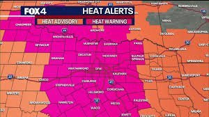
The heat is not just uncomfortable; it is becoming hazardous. In the Dallas-Fort Worth area, temperatures are projected to soar to 107 degrees, with heat index values—the “feels like” temperature—surpassing a staggering 110 degrees. This combination of intense sun and high humidity has triggered extreme heat warnings across much of the region.
For those monitoring the broader National Weather Service updates, it is clear that this high-pressure system is creating a “heat dome” effect, trapping hot air and making it difficult for temperatures to drop even at night.
Will Isolated Showers Bring Relief?
There has been a glimmer of hope in the form of isolated showers and thunderstorms. Early reports indicate that storm clusters have moved through the Brazos Valley and southern counties, including Johnson and McLennan. However, these weather events have been largely sub-severe and limited in scope.
Unfortunately, for those hoping for a cooldown, these spotty showers are not enough. Here is why the rain isn’t solving the problem:
- n
- Limited Coverage: Only about 10% of the region is seeing significant rainfall.
- Brief Duration: Most afternoon showers are brief and isolated, providing only temporary respite.
- Worsening Drought: The meager precipitation is failing to alleviate Stage 1 drought conditions currently implemented across North Texas.
The Week Ahead: When Will it Cool Down?
If you are planning your week, prepare for more of the same. The forecast suggests that the peak of the heatwave will persist into early next week, with highs potentially reaching 108 degrees on Monday and 107 degrees on Tuesday.
The good news? A slight cooling trend is on the horizon. As the high-pressure system weakens toward midweek, temperatures are expected to dip slightly to around 103 degrees by Wednesday and 101 degrees by Thursday. There is also a 20% chance of rain returning by the end of the week, which could provide some much-needed moisture to the parched soil.
Stay Safe in the Heat
Whether you are dealing with the humid Houston weather or the dry heat of North Texas, safety should be your priority. Remember to stay hydrated, limit outdoor activities during peak sun hours, and check on elderly neighbors and pets.



