
Brace for Impact: The Coming ‘Super’ El Niño and Your Winter Snow Outlook
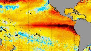
As we look toward the 2026-27 winter season, the climate signals are flashing a warning: a very strong El Niño is brewing in the Pacific. According to the latest data from NOAA’s Climate Prediction Center (CPC), the probability of a high-intensity event has surged to a staggering 95%. But what does this mean for your winter plans, your heating bill, and—most importantly—the snow?
Understanding the relationship between oceanic warming and atmospheric response is key to predicting whether we’ll face a white winter or a mild anomaly. Here is everything you need to know about the upcoming seasonal shift.
The Science Behind the Surge: What is RONI?
Climate scientists are closely monitoring the Relative Oceanic Niño Index (RONI). Recent forecasts place the median October-December value at +2.66°C (+4.8°F). To put this in perspective, this level would exceed almost every El Niño event recorded by NOAA since 1950.
When the central and eastern equatorial Pacific warm up this significantly, it disrupts the jet stream, acting like a giant atmospheric steering wheel that pushes storms and cold air into new territories.
Where Will the Snow Fall? (And Where Won’t It?)
The most critical question for residents in North America is how this affects snowfall. While temperature patterns provide a broad guide, snow is notoriously difficult to predict because it requires the perfect marriage of moisture and freezing temperatures.
- n
- Lower Snowfall Expectations: The Northwest and northern-central United States, along with southern Canada, are likely to see below-normal precipitation and lower overall snowfall.
- Higher Snowfall Potential: In a classic El Niño shift, we expect higher snowfall totals across the central and eastern United States and southeastern Canada.
- The Southern Tier: Much of the southern US is expected to be wetter than normal, though whether this moisture falls as rain or snow depends on the strength of individual cold waves.
A Global Perspective: Canada and Europe
The influence of this ‘Super’ El Niño extends far beyond US borders. In Canada, the contrast will be sharp: warmer conditions in the West and North, but a potential for heavy snow in the East.
In Europe, the connection is less direct. However, data from the Copernicus Climate Change Service (C3S) suggests a potential for a mild, windy start to the winter, with higher snowfall limited mostly to mountainous and northeastern regions. The North Atlantic Oscillation (NAO) will play a deciding role in whether Europe experiences a traditional white winter.
The ‘Wild Card’: Why Stronger Isn’t Always Simpler
It is a common misconception that a ‘Very Strong’ El Niño is simply an amplified version of a moderate one. Research indicates that extreme events can cause an eastward shift in atmospheric teleconnections. This means the typical patterns we expect might shift further east than usual.
Additionally, the Indian Ocean Dipole (IOD) is showing signs of a positive phase. When the Indian Ocean warms alongside the Pacific, it can either amplify or counteract the El Niño effect, adding another layer of complexity to our winter weather predictions.
Final Thoughts for Winter 2026-27
While the probabilities point toward a record-breaking event, remember that climate models predict trends, not specific storms. Whether you are a ski enthusiast hoping for deep snow or a homeowner dreading the freeze, staying updated with real-time situational intelligence is essential.
Stay tuned for the next official seasonal outlook from the CPC on August 20 for refined regional probabilities.



