
Brace Yourselves: A Weekend of Severe Weather Ahead for Eastern Canada
If you’ve noticed the air becoming increasingly thick and muggy over the last few days, you aren’t alone. This oppressive humidity is setting the stage for a volatile atmospheric shift. A potent cold front is currently pushing into the region, acting as a catalyst for a round of severe weather that could disrupt weekend plans across Ontario and Quebec.
From localized flooding to damaging winds, the atmosphere is primed for instability. Here is everything you need to know to stay safe and prepared.
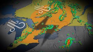
When and Where: The Storm’s Path
The weather activity is expected to trigger a sequence of events starting Saturday morning. The progression will likely follow this pattern:
- Greater Toronto Area (GTA): The weekend kicks off with heavy rainfall tracking into the region early Saturday.
- Kingston to Ottawa: As the system moves east, precipitation will evolve into thunderstorms, with a high probability of becoming severe.
- Northeastern Ontario & Western Quebec: Peak afternoon heating will likely fuel the most intense discrete thunderstorms in these areas.
- Southern Ontario: By Saturday evening, the risk shifts back south as lake breezes interact with the advancing cold front.
What to Expect: The Primary Risks
This isn’t your typical summer drizzle. The combination of high atmospheric moisture and a sharp cold front means several hazards are on the table:
- Damaging Wind Gusts: Strong outflows from thunderstorms could cause property damage or downed branches.
- Large Hail: Intense instability in the upper atmosphere increases the risk of hail in the strongest cells.
- Localized Flooding: With a rich reservoir of moisture available, rainfall rates could be extreme, leading to flash flooding in urban and low-lying areas.
- Isolated Rotation: While less common, environmental conditions in Western Quebec and Northeastern Ontario suggest that isolated rotation cannot be entirely ruled out.
The ‘Wildcard’ Factor: Wildfire Smoke
Interestingly, there is one factor that might act as a stabilizer. A layer of upper-level smoke from wildfires in Western Canada is being carried into the region. This smoke can sometimes act as a “cap,” potentially suppressing the overall severity of the storms. However, this is an uncertainty, and residents should not let their guard down.
How to Stay Safe
When dealing with severe weather, vigilance is your best defense. We strongly recommend monitoring official alerts from Environment Canada to receive real-time warnings and watches for your specific coordinates.
Quick Safety Checklist:
- Secure outdoor furniture and loose items.
- Ensure your mobile devices are charged for emergency alerts.
- Avoid travel during the peak of the storms, especially in flood-prone areas.
- Have a designated indoor shelter if a severe thunderstorm warning is issued.
Stay tuned for further updates as the front progresses. Keep an eye on the sky and stay safe, Canada!



