
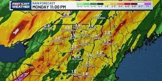
Prepare for Heavy Rainfall: Flood Watch Issued for the Northeast
After a tranquil start to August and a beautifully sunny Saturday, weather patterns are shifting rapidly. Residents across New York, Vermont, and New Hampshire should prepare for a transition from calm skies to heavy downpours and potential flooding starting late Sunday and continuing through Monday.
While the region enjoyed a brief respite, the arrival of a new weather system brings the risk of significant precipitation, prompting a closer look at a potential flood watch for vulnerable areas.
Timeline of Expected Weather Events
The weather shift will happen in stages, moving across the region as follows:
- n
- Sunday Morning: Light showers will begin moving into New York.
- Sunday Afternoon & Evening: Rain will become more frequent and intense. Specifically, the St. Lawrence Valley may face isolated flash flooding risks during this window.
- Monday: Occasional showers and heavy downpours will persist across the region before gradually clearing out by Monday evening.
Potential Impacts and Rainfall Amounts
Meteorological models suggest that while the rain will be widespread, the intensity will vary. Some localized areas could see rainfall totals exceeding 2 inches. When high volumes of water fall in a short period, the risk of flash flooding increases, particularly in low-lying areas or urban centers with poor drainage.
For real-time updates and official safety guidelines, it is highly recommended to monitor the National Weather Service (NWS) to stay informed about current warnings and watches in your specific zip code.
Thunderstorms and Future Outlook
Although severe weather—such as damaging winds or hail—is not expected, the region should be prepared for embedded thunderstorms. These storms are often the primary drivers of the heavy downpours that lead to localized flooding.
The Good News: Northern regions have been experiencing a dry spell and could benefit from this moisture, which may naturally mitigate the overall flood threat in those specific areas.
Looking ahead, the weather is expected to stabilize quickly. Tuesday promises a much quieter start to the mid-week, with mostly sunny skies and fair temperatures returning to the region.



